|
Deschutes National Forest
1001 SW Emkay Drive
Bend, OR 97702
(541) 383-5300
Ochoco National Forest
3160 N.E. 3rd Street
Prineville, OR 97754
(541) 416-6500
Crooked River National Grassland
813 S.W. Hwy. 97
Madras, OR 97741
(541) 475-9272
|

|
|
Geology
Oregon Volcanoes
South Sister Volcano
SUMMARY
Type: stratovolcano
Activity: dormant
Last Eruption: about 1,900 yrs ago
Rock Type: basaltic andesite to rhyodacite.
Eruptive Volume: ?
Latitude: 44.10 N
Longitude: 121.77 W
Location Maps: from TIGER Mapping Service
Topo
Map from TopoZone
South Sister Photo Menu
GEOLOGIC BACKGROUND:
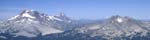
The Three Sisters area contains 4 large cones of Quaternary age
-- North Sister, Middle Sister, South Sister, and Broken Top.
- North Sister and
Broken Top are deeply dissected and probably have been inactive
for at least 100,000 years.
- Middle Sister younger than
the North Sister and older than the South Sister. It was active
in late Pleistocene but not postglacial time.
- South Sister is the least dissected; its basaltic andesite
summit cone has a well preserved crater. Most of South Sister
predates late Wisconsin glaciation and is therefore older than
25,000 years; however, eruptions of rhyolite from flank vents
have occurred as recently as 2000 years ago. Map
of Holocene Tephras (22k gif)
The latest eruptions on South Sister, which occurred in two closely
spaced episodes about 2,000 years ago, illustrate a relatively
modest scale of eruptive activity. Initial explosive eruptions
produced small pyroclastic flows and tephra fallout from several
aligned vents low on the south flank. Tephra fallout deposits
more than 2 meters (7 feet) thick, composed of pumice, rock fragments,
and ash, blanketed areas within 2 kilometers (1 mile) downwind
of vents; at 13 kilometers (8 miles) about 10 centimeters (4 inches)
fell. Less than one centimeter (0.5 inch) of ash fell at least
as far as 40 kilometers (25 miles) south of the vents (at Cultus
Lake) and east of the vents (at Bend). Following tephra eruptions,
lava emerged from two vent areas, forming a large lava flow, Rock
Mesa, and several small lava domes. Decades to a few centuries
later, a similar eruptive sequence occurred along a zone of vents
that extended from just north of Sparks Lake to high on the southeast
flank of South Sister, as well as along a shorter zone on the
north flank near Carver Lake. Similar-style eruptions, but up
to about ten times larger in terms of volume of ejecta, occurred
during and just before the last ice age, about 30,000 to 15,000
year ago. Excerpt from: Scott,
et.al., 2001, Volcano Hazards in the Three Sisters Region,
Oregon: USGS Open-File Report 99-437
HISTORIC ACTIVITY:
RECENT ACTIVITY:
-
During the period from about 10 am on March 23, 2004 to about
1 am on March 25 a swarm of earthquake occurred in the Three
Sisters area. More than 100 small quake up to a magnitude of
1.9 occurred. Seismograms
of swarm.
-
On May 8, 2001, U.S. Geological Survey scientists reported
that by using Satellite
Radar Interferometry (or InSAR) they had detected a broad
area over which the ground has swelled upward slightly during
the past few years. The area is centered 5 kilometers
(3 miles) west of South Sister volcano in the Three Sisters
region of the central Oregon Cascade Range. The area of uplift
is about 15 to 20 kilometers (9 to 12 miles) in diameter and
the maximum amount of uplift at its center is about 10 centimeters
(4 inches).
DATA SOURCE:
ADDITIONAL INFORMATION
- Link to U.S.G.S. - CVO
- Link to U.S.G.S. Visit a Volcano Info for Three
Sisters
- Link to University of Washington Geophysics Program Information
- Link to VolcanoWorld
|
|

|

