PETREL SUB-BASIN, BONAPARTE BASIN, NORTHERN TERRITORY
The Petrel Sub-basin is a northwest-trending Paleozoic rift within the southern Bonaparte Basin, located offshore northwestern Australia in the Joseph Bonaparte Gulf. Water depths are generally less than 100 m. The Petrel Sub-basin is an emerging hydrocarbon province with limited existing infrastructure in place. Release areas on the eastern side of the sub-basin are under-explored with limited well and seismic coverage. However, areas that are proximal to gas discoveries have good petroleum well and seismic distribution.
Reservoir: Plover Formation of the Troughton Group and the Sandpiper Sandstone (Flamingo Group).
Seal: Frigate Formation of the Flamingo Group and Bathurst Island Group regional seals.
Trap: Faulted anticlines, stratigraphic traps, salt diapers, and migration dissolution/residual trapping.
Refer to Gibson-Poole et al., 2002 for stratigraphic information.
PTRL-01 AND PTRL-02, Petrel Sub-basin, Bonaparte Basin
PTRL-01 and PTRL-02 are located along the eastern margin of the sub-basin and are approximately 200 km west of Darwin within the Joseph Bonaparte Gulf (Figure 1). The western edge extends into Western Australia.
Release area PTRL-01 comprises of 204 graticular blcoks and covers an area of approximately 17025 square kilometres and 204 graticular blocks (Figure 2). Release area PTRL-02 covers an area of approximately 21160 square kilometres and 270 graticular blocks or parts thereof (Figure 2).
Overlapping Petroleum Exploration Titles
Release Areas | Overlapping Petroleum Titles | Petroleum Title Holders |
PTRL-01** | | |
PTRL-02 | NT/P66 | Nexus Energy Ltd |
NT/P77 | Essar Exploration and Production Ltd |
NT/P78 | Essar Exploration and Production Ltd |
WA-279-P | ENI Australia Ltd |
WA-313-P | ENI Australia Ltd |
** There are no overlapping petroleum titles over the Release area PTRL-01. However, PTRL-01 overlaps petroleum release areas, NT08-01, NT08-02 and NT08-03, which were released in the 2008 Petroleum Acreage Release process. Bids for these three petroleum areas will close on 9 April 2009.
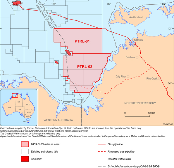
Figure 1. Location map of offshore Greenhouse Gas Storage release areas for Assessment PTRL-01 and PTRL-02, Petrel Sub-basin, Bonaparte Basin.