Highlights – Release Areas NT09-Special and W09-Special, Petrel Sub-basin, Bonaparte Basin
In this section
Bids Close – 03 December 2009
- Under-explored, shallow water areas (<50 m) in a proven Paleozoic oil and gas province.
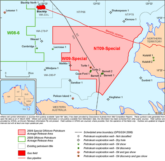
- Release Area NT09-Special contains the Barnett oil accumulation. Release Area W09-Special contains the Turtle oil accumulation. Both Release Areas are within close proximity to the Petrel, Tern and Blacktip gas fields and the Blacktip pipeline.
- Play types include, horst-blocks, rotated fault-blocks, faulted anticlines, salt associated structures, stratigraphic traps, pinchouts and unconformity truncations.
- Proven oil and gas-prone Carboniferous Langfield Group source rocks, potential gas-prone Carboniferous–Permian source rocks.
- Most prospective reservoirs occur in the Carboniferous Weaber and Wadeye groups, and the Carboniferous–Permian Kulshill Group. The Early Triassic Ascalon Formation is the shallowest reservoir in the Blacktip gas field.
- Good quality Permian Treachery Formation and Fossil Head Formation regional seals.
- Special Notices apply, refer to Guidance Notes.
Petrel Sub-basin Petroleum Play elements
Source | Oil and gas sourced from the Early Mississippian Langfield Group. Potential gas-prone Carboniferous–Permian source rocks. |
|---|
Reservoir | Reservoirs include: Mississippian Weaber Group (Kingfisher Shale, Tanmurra Formation and Milligans Formation), Mississippian–Pennsylvanian Wadeye Group (Arco and Aquitaine formations), Pennsylvanian–Cisuralian Kulshill Group (Kuriyippi Formation, Treachery Formation and Keyling Formation). The Early Triassic Ascalon Formation is the shallowest reservoir in the Blacktip gas field. The Permian Hyland Bay Subgroup (Torrens, Cape Hay and Tern formations) are good quality reservoirs in the Petrel, Tern and Penguin gas accumulations. |
|---|
Seal | Good quality Cisuralian Treachery Formation and Fossil Head Formation regional seals. Intra-formational seals within the Mississippian Weaber Group. |
|---|
Traps | Play types include, horst-blocks, rotated fault-blocks, faulted anticlines, salt associated structures, stratigraphic traps, pinchouts and unconformity truncations. |
|---|
Infrastructure and Markets | The Release Areas are close to the Petrel, Tern and Blacktip gas fields. Gas from Blacktip will be piped to Darwin via the onshore gas plant near Wadeye and the Bonaparte trans-territory pipeline. This pipeline connects to the existing pipeline transporting gas from the Amadeus Basin to Darwin. |
|---|
Release Area NT09-Special, Petrel Sub-basin, Bonaparte Basin, Northern Territory
Graticular Block Listing
Map Sheet SD 52 (Darwin)
| 1834 (part) | 1835 | 1836 | 1837 | 1838 | 1839 |
| 1840 | 1841 (part) | 1842 (part) | 1906 (part) | 1907 (part) | 1908 |
| 1909 | 1910 | 1911 | 1912 | 1913 (part) | 1979 (part) |
| 1980 | 1981 | 1982 | 1983 | 1984 (part) | 1985 (part) |
| 2051 (part) | 2052 (part) | 2053 | 2054 | 2055 | 2056 (part) |
| 2124 (part) | 2125 | 2126 | 2127 (part) | 2128 (part) | 2196 (part) |
| 2197 (part) | 2198 | 2199 (part) | 2269 (part) | 2270 (part) | 2271 (part) |
| 2341 (part) | 2342 (part) | | | | |
Assessed to contain 44 blocks (includes 21 full blocks and 23 part blocks)
Graticular Block Map
Release Area W09-Special, Petrel Sub-basin, Bonaparte Basin, Western Australia
Graticular Block Listing
Map Sheet SD 52 (Darwin)
| 1832 | 1833 | 1834 (part) | 1904 | 1905 | 1906 (part) |
| 1907 (part) | 1978 | 1979 (part) | 2049 | 2050 | 2051 (part) |
| 2052 (part) | 2122 | 2123 | 2124 (part) | 2195 | 2196 (part) |
| 2197 (part) | 2269 (part) | 2341 (part) | | | |
Assessed to contain 21 blocks (includes 10 full blocks and 11 part blocks)
Graticular Block Map
For convenience, geographical coordinates shown on this map are expressed in terms of the Geocentric Datum or Australia 1994 (GDA94). Permit areas are defined by the 5 minute graticular block system set out under Section 16 of the Offshore Petroleum and Greenhouse Gas Storage Act 2006; under Sections 20, 21 and 21A of the Act, the position of those blocks is determined by reference to the Australian Geodetic Datum (AGD66).