Crusty old Joe's
Kodiak Alaska Military History
The official web site of the Kodiak Military History Museum
Woody Island
Woody Island is located in Chiniak Bay just adjacent to the city
of Kodiak. There is no public transportation to the island.
Except for a wilderness area belonging to Alaska State Parks,
most land on Woody is private property.
The topo map is Kodiak D-1 SW.
Latitude: 57 47 05 N Longitude: 152 19 43 W.
For a map showing where the island is located, click
here. You can clearly see Woody Island and others from
this photo taken from
Pillar Mt. at about 1300 feet.
While we do not advocate any position regarding legal proceedings
in this case, there is quite a bit of Woody Island history
contained in
this document.
In 1894 the US Post Office officially designated it Wood Island.
From 1852 to 1872 the American Russian
Commercial Company operated an ice industry here.
The first iron rails and horses in Alaska were brought to
Woody Island to help haul ice and run the horse-powered saw which cut the
ice into blocks. The first road in Alaska was built around the island to
exercise the horses.
The mission was established on
Wood Island in 1893. Within the
next twenty years the mission built and expanded their facilities to
include the main building with girls quarters and dining room, a boys
dormitory, office building, barn, carpenter shop, cannery, and silo. In
1925, the main building was burned by fire, immediately rebuilt, and
burned again in 1937. The
mission then relocated to its present site on Mission Rd. in Kodiak.
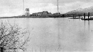
 In 1911, the navy built a wireless station on Woody Island
consisting of two masts 225 feet high and 400 feet apart. The wireless
building was struck by lightning during the volcanic eruption of 1912 and
burned down. It was rebuilt and modernized in 1914. The new masts were anchored in
large cement blocks under the ground this time.
It is interesting to note
that after the earthquake and subsequent tidal activity in 1964, all of
the earth had been completely washed away from one of these huge blocks
which is now visible.
On February 28, 1931, the wireless station was decommissioned and shortly
thereafter the Territory of Alaska was given permission to use the
associated buildings for the Longwood
School.*
The photo on the right is a post card dated 1915 owned by Trish Hampton.
In 1911, the navy built a wireless station on Woody Island
consisting of two masts 225 feet high and 400 feet apart. The wireless
building was struck by lightning during the volcanic eruption of 1912 and
burned down. It was rebuilt and modernized in 1914. The new masts were anchored in
large cement blocks under the ground this time.
It is interesting to note
that after the earthquake and subsequent tidal activity in 1964, all of
the earth had been completely washed away from one of these huge blocks
which is now visible.
On February 28, 1931, the wireless station was decommissioned and shortly
thereafter the Territory of Alaska was given permission to use the
associated buildings for the Longwood
School.*
The photo on the right is a post card dated 1915 owned by Trish Hampton.


Early Radio Communications in the Thirteenth Naval District Washington, Oregon and Alaska
Prepared for the OLD TIMER COMMUNICATORS by George B. Todd, LT USN RET.
U.S. Naval Radio Station, Kodiak (NPS):
(a) Located at Woody Island, Kodiak, Alaska. Euipped wtih one 7.5 KW 500 cycle
quenched spark set adjusted to the following wavelengths: 600, 952, 1905 and 2400 meters.
(b) Radio Communication: Effective with St. Paul, Cordova, Seward, Sitka, Ketchikan,
Anchorage, Latouche, and with ships equipped with spark apparatus dependent on their range,
and at night only with Dutch Harbor ad North Head. Can be effected at night only with
Tatoosh, but North Head provides better results.
(e) Comment: This station handles commercial traffic both with shipping and point to
point in Alaska and to the United States. Kodiak now acts as a relay station between the
westward stations (Naval stations and cannery stations) and Cordova, but a new satisfactory
schedule is being worked between Cordova and St. Paul which will cut out unnecessary relays
and leave Kodiak in a better position to handle local traffic from cannery stations in the
vicinity.
ALASKAN NAVAL RADIO EXPEDITION, 1912
Appendix A-14, page 295
KODIAK
(Note: The village of St. Paul below refers to what it now the town of Kodiak.)
The Kodiak station is located on Woody Island, about two
miles from the village of St. Paul on the main island. With
the exception of the masts, the station had been totally
destroyed on June 8, 1912, when struck by lightning during
eruption of Mt. Katmai(sic). There was a depth of ashes, or
rather powdered pumice, for about 8 to 12 inches all over the
land. The only article left in the ruins of the old station
which was of any value was a 15-H.P. gas engine, which was
returned to Mare Island by the Nero and afterwards repaired.
All material for the new station was landed in three and a
half days. A combined dwelling and power house was erected,
with shingle roof and sides, storm windows fitted throughout
and a glass porch built outside the operating room. The
inside of the building was finished with plaster board and
battens. The dwelling was fitted with electric lights and
equipment for all rooms, including kitchen and bath. A
water system was installed with a 500-gallon tank in the
attic, a 2,500-gallon redwood tank just outside the power
house, and a 2-H.P. gasoline-driven pump. Water was pumped
through pipe line from a well near the station.
Two 12-H.P. Meitz and Weiss kerosene engines were installed
on a 44-ton concrete foundation, with 5-kw, 500-cycle
alternator. A 3-kw generator was setup for electric lighting
and charging storage batteries. The engines were equipped with
constant-burning lamps and necessary tanks. Three
1,000-gallon kerosene fuel tanks and one 500-gallon gasoline
fuel tank were set up in the same manner as the ones at
Dutch Harbor.
In the operating room was installed the 5-kw, 500-cycle
quenched-spark, experimental radio set, designed by Expert
Electrical Aide George E. Hanscom. The set permitted rapid
changes in wave-length settings from 300 to 6,000 meters,
the latter being greater than obtained in any other station on
the Pacific Coast. A new ground plate was put in and connected
to the ground of the old station, and, as usual, to all
ground leads and protective devices.
New rigging was set up on both of the 225-foot wooden
lattice masts and a main flat-top 8-wire aerial was installed,
length 375 feet, spread 40 feet, 4 down leads at eastern end,
bunched at top and stopped together all the way down.
There was installed a single-wire aerial, "T" type (ten feet
above main aerial) for receiving and for sending on short wave
lengths. The station was furnished with a lathe, equipment
for the dwelling and power house, and supplies for about one
year.
An auxiliary station was established in the town of St.
Paul to facilitate local communication. This station has a
60-foot mast, with a 4-wire vertical aerial, length 75 feet,
spread 6 feet. A radio set, which was the usual storage-battery
outfit, was installed in a one-room cottage built on the
U.S. Customs Reservation.
The new Kodiak station was commissioned at 12:01 A.M.,
November 1st, eighteen days after the arrival of the expedition.
Immediate communication was established with Cordova,
Sitka and Unalga, and the next night with other Alaska
stations and with Pacific coast stations as far south as Mare
Island. On November 2d, the Mare Island operator, without
previous intention or notification, tested all the new Alaska
installations by calling in succession, Cordova, Kodiak,
Unalga, Dutch harbor and Pribilof, and obtained the daily
weather report from each. The time required was less than
thirty minutes.
The Nero left Kodiak November 5th, 1912, for Sitka.
The cost of the Kodiak station, including an estimate of
$5,000 for the purchase of the land on which the station was
built, was $23,283.
Bart and Betty Phelps arrived on Woody Island in July, 1924. Bart spent a
year as a Radioman on the Station. Their son was born there just before
they left.
Earlier in it's history, Woody Is. had a sawmill to make insulating
sawdust for the ice that was produced here. Later and for
a short time Army
personnel set up and ran a sawmill to produce lumber for
the building needs of the armed forces. Lumber was rare in Alaska and it
was thought that several of the surrounding islands
could provide some.
After cutting 4.5 million feet of lumber on Woody from
March to November 1942, the Army lumber crew moved its operations to
Afognak Island.
The Federal Aviation Agency (FAA) greatly added to Woody history
for nearly thirty years beginning in 1941.
The FAA station was first manned by a meager staff of technicians
who all stayed in very close dormitory quarters. During the war the
number of FAA personnel on Woody Island grew to forty. To make living
arrangements more livable a number of couples solved the privacy problem
by moving across the island into old Navy buildings.
As many as seven to nine aircraft communicators
were needed at a time to furnish the weather and other aeronautical data
to pilots twenty-four hours a day. The war demanded that everyone work
seven days a week to make repairs to the teletypes, transmitters, radio
receivers, boats, and trucks that brought the supplies and equipment to
the island. More quarters were greatly needed and, in 1948, a large Navy
building on west Woody was converted into seven apartment units. By 1949,
two more apartment buildings with five units each were built and once
again Woody was home to a small community. The badly needed school was
finally built on east Woody in 1951. An enrollment of 27 and a second
teacher was enough reason for an addition to the school house in 1957.
The FAA operated a ferry boat, the Fedair IV.
Darrell F. Chaffin was the manager
of FAA operations on the island and later the entire area.
In 1979 most of the FAA complex burned to the ground
In 1979 the FAA TRAPLINE newsletter published an article titled
FAA COMMUNITY ON WOODY ISLAND 1941-1973.
Page 1, Page 2.
Some people who worked for the CAA/FAA on Woody Island are:
Don Thomas station manager 1954,
Howard Slonager,
Zip Zaber,
Jim Cusack,
Stan Ericson,
Darrell F. Chaffin station manager,
Yule Chaffin,
Dick Inman,
Moon Mullins,
Norman E. Harrington 1949-50 (who wrote a
FINE article about Woody Is),
Chuck Irwin,
Mel Holroyd,
John Bassler,
Anthony T. Giambruno,
Morris (Pappy) Lee,
Robert E. Thomas.
For a perspective from the summer camp operated on Woody Island,
see
this.
During World War II there was a "Magnetic Loop Station" on Woody.
This is a
big loop of wire placed on the bottom of the harbor
entrances to act as a metal detector whenever an enemy submarine
might pass over the loop. The Japanese had many midget submarines
capable of entering the harbor. The largest loop ran between the
tip of Cliff Point and the south tip of Woody Is. The other loop
ran between Woody Is. and Kodiak Is. about midway along the channel
between the two islands. (Data from the Harbor Defenses of Kodiak,
1 November 1944.) For further reading about magnetic loops, see
this web page about
Ft. Tilden at New York Harbor or
this one.
For details of the USN Net Depot on Woody Island, see
this photo album.
Quoting from the official Navy base history:
"On Woody Island, Northeast of St. Paul's Harbor, are located Magnetic
Loop and Harbor detection equipment, net depot, and nets for anti-submarine
detection and the C.A.A. (Civil Aeronautic Authority) Range Station for air
traffic.
In October, 1942, a heavy indicator net for surface and under surface
vessels consisting of 200' panels, was stretched from Woody Island to Shahafka
Cove. If a 200' section of this net was carried away, the net vessel, equipped
with depth charges, went into action. This net was approximately 1500 yards
long with a 600' gate in the ship channel. It was opened and shut by two YP
boats, one of which was on duty at all times. Equipped with anti-aircraft guns
and radio these YP boats signaled the approach of all aircraft to Woody Island
signalman, who relayed this information to the aircraft clearance tower on
the base.
In November, 1943, anti-torpedo nets, 30' deep, for protection against
the torpedo rather than the submarine, were substituted for the heavier nets
installed in October, 1942.
In December, 1942, magnetic loop stations were installed at the entrance
of the channel leading to Kodiak and at St. Paul's harbor. (see photograph of
Woody Island, showing Loop Station and Net Depot, appendices #30).
A navy Communications Radio Compass Station was set up on Woody Island
during the first World War and is still in operation. The CAA was
commissioned 22 June 1941 as a Radio range.
"
Many technical manuals from the
radio range station are in the museum's collection.
These maps are in the collection of the Kodiak Military History Museum.
They are much too big to scan and present on this web site.
You can make an appointment to inspect them by sending e-mail to
the address below. Where interest has been demonstrated, portions have been scanned.
Plat of US Survey 603 of the Russian Greek Church Mission Reserve
Tract A 0.12 acres, Tract B 1.46 acres
scale 1 chain to the inch
Frank H. Lascy US Deputy Surveyor August 6-8, 1905
registered in Juneau April 7, 1908
Shows no features except bounds.

Plat of US Survey 626 of the Baptist Mission Reserve, 962.77 acres
scale 8 chains to the inch
Frank H. Lascy US Deputy surveyor August 8-14, 1905
registered in Juneau April 7, 1908
Shows 2 RGM tracts, lakes a b c and Una Lake.
Near lake a (Icehouse Lake) shows over 20 structures.
Main survey start labeled "USLMRGMWITA"


August 27-29, 1913, J. Frank Warner, Surveyor.  Filed in Juneau Apr 13, 1914.
Plat of U.S. Survey No. 484 U.S. Naval Reserve, 8.39 acres, scale 2 chains = 1 inch.
Shows radio antenna, dock, ship slip, carpenter shop, barn, house, native house,
and a fenced garden within the Navy Reserve.  Outside is shown a school, playground,
house, barn, log building.  All this generally in the area between the lake and
the pier.
Map portion showing US Naval Reserve, Wireless Apparatus, Dock:
  Note: The map is negative, white lines on black.  These images are reversed.
  1700x2200
  371x480

January 8, 1942, drawn by GRA.  DR. D8-61-6
General Plan Radio Facilities. Civil Aeronautics Administration, 8th region, Anchorage.
Scale 1 inch = 500 feet.
Shows quarters and control site on the east side.  Just north of that is shown
a range site with antennas on the northeast side of Elephant Lake.
Further north-northwest of that site is shown a communication site with three
300 foot towers and other masts and a generator building.
Roads and a right-of-way are shown.  USGLO Surveys No. 626, 1674, 1675.

September 19, 1942, Kodiak field drawing K-4-10334, NAS No. 10334
GENERAL LAYOUT NET DEPOT ICEHOUSE POINT WOODY ISLAND
Contract NOy-3570 Alaskan Air Base Construction, Siems Drake Puget Sound
With red markings update June 1, 1948
Large map with many details. 1 inch = 100 ft.

May 13, 1943, drawn by EAC, DR. 8D-61-4
PROPERTY TIES WOODY ISLAND -(KODIAK)
Civil Aeronautics Admin.
scale 1 inch = 8 chains
Lakes a b c penciled-in as Ice House Lake, Long Lake, Lake Tanignak.
Shows corners only.  No structures.

April 4, 1944, revised 2 Dec 52
WOODY ISLAND NET DEPOT & MAGNETIC LOOP STATION
Scale 1 inch = 100 feet, NAS Drawing No. K-3-14,120
Shows very detail of area around Ice House Lake.
Excellent map.  Have 3 copies.
Portion of map showing Magnetic Loop Station, Pier, Shop area.
  1700x2200
  480x342
Portion of map showing Barracks, Mess, BOQ, Pump House.
  1700x2200
  480x371
Map from ANNEX showing magnetic loops.

November 4, 1949, drawn by BBC, 8D-61-4A, J.C. Hooper, G.O. Kempton
Real Estate Data, CAA
scale 1 inch = 500 feet
USGLO Survey No. 626, Women's American Baptist Home Mission Society
Detail of Navy Res. & 13.82 acre tract.
US Navy res. US survey No. 484, 8.39 ac. (by Ice House Lake)
 shows 11 numbered structures on Navy land

  Chart of land acquisition:
  Tract A - contract ANSW No. 179 - from BLM 728 ac less prior rights USS 626, 227 ac.
            date 7/21/42
  Tract B - contract C8CA-1037 - from Women amer bap mis soc, ct cable r/w
            date 6/30/42 - 6/30/63
  Tract C - contract C8CA-3097 - from women amer bap mis soc, RD. R/W
            date 7/1/55
  Tract E - rev permit - from US Navy, fuel storage incl pipe line R/W
            date 10/17/45
  Tract F - permit - US Navy, bldg use
            date 12/3/52

  Chart of Land Occupation
  Tract A - permit, terr dept of ed etc, school, 0.568 acres
            date 9/1/52 - 6/30/72

Thirteen pages traverse data, loose with paper clip, yellow ledger pages.
WOODY ISLAND NET DEPOT & MAGNETIC LOOP STATION - undated
STRUCTURE LIST
1 - machine shop
2 - garage
3 - carpenter shop
4 - school teachers residence
5 - school
6 - net depot office
7 - paint shop
8 - blacksmith shop & power plant
9 - shed
10- electric shop
11- fire house
12- barrack - loop personnel
13- bosn's locker
14- loop station generator
15- loop station
16- loop station officers quarters
17- storehouse (sh-8)
18- storehouse - nets
19- barracks - net depot (B-63)
20- mess hall (nets & loop personell)(M-33m)
21- officer quarters (OQ-7)
22- power plant
23- pump station - water
24- water tank - wood stave

Letter: 25 May 1964
from C.O. Navy Station Kodiak
disposal of Woody Is. property:
3.51 ac, 4.88 ac, 1.35 ac.
This is a sample of a very large file of property disposal letters
between the Navy and the FAA.
Woody Island Net Depot page.
Radio Range Station
Contact us.
Main index
Other web sites:
Building the Navy's Bases in World War II: History of the Bureau of Yards and Docks and the Civil Engineer Corps, 1940-1946
Salvage of Chirikof range in 1949.
Radio Station Operations in Kodiak, Alaska in 1924-1925
Personal Recollections of Harold B. Phelps, Lt. USN (ret)
References:
(1) Early Radio Communications in the Thirteenth Naval District Washington, Oregon and Alaska -
Prepared for the OLD TIMER COMMUNICATORS by George B. Todd, LT USN RET.
http://www.kadiak.org/woody_is/index.html
This page updated 2014 April 11
 In 1911, the navy built a wireless station on Woody Island
consisting of two masts 225 feet high and 400 feet apart. The wireless
building was struck by lightning during the volcanic eruption of 1912 and
burned down. It was rebuilt and modernized in 1914. The new masts were anchored in
large cement blocks under the ground this time.
It is interesting to note
that after the earthquake and subsequent tidal activity in 1964, all of
the earth had been completely washed away from one of these huge blocks
which is now visible.
On February 28, 1931, the wireless station was decommissioned and shortly
thereafter the Territory of Alaska was given permission to use the
associated buildings for the Longwood
School.*
The photo on the right is a post card dated 1915 owned by Trish Hampton.
In 1911, the navy built a wireless station on Woody Island
consisting of two masts 225 feet high and 400 feet apart. The wireless
building was struck by lightning during the volcanic eruption of 1912 and
burned down. It was rebuilt and modernized in 1914. The new masts were anchored in
large cement blocks under the ground this time.
It is interesting to note
that after the earthquake and subsequent tidal activity in 1964, all of
the earth had been completely washed away from one of these huge blocks
which is now visible.
On February 28, 1931, the wireless station was decommissioned and shortly
thereafter the Territory of Alaska was given permission to use the
associated buildings for the Longwood
School.*
The photo on the right is a post card dated 1915 owned by Trish Hampton.
