Hydroinformatics and Management Systems
MSc, Diploma, Certificate and Professional Development Courses for Water Industry Professionals
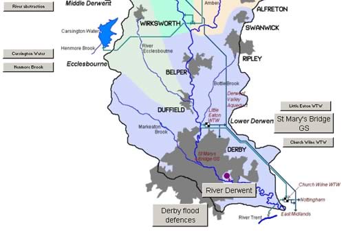
A Brief Tour of the Derwent
The Lower Catchment
|

The River Derwent
The River Derwent on the northern edge of Derby
This is the catchment lowland zone, characterised as a deposition zone where the river deposits sediment. Also, having collected all the pollution from the catchment, water quality can be poor. Flows are high, and high rainfall further up the catchment can cause extensive flooding, requiring a mixture of a large floodplain and flood defence works.
[ Back to top of page ]
|
Flood Defences at Derby
|

Floodplain
Development on the floodplain in Derby
On both sides of the normal river channel is the floodplain, allowing river self regulation for high flow events. The floodplain is normally dry, so vegetation will therefore increase the roughness, reducing flow velocity and so contributing to storage and flood attenuation. Where there is development on the floodplain flood defence works are necessary.
[ Back to top of page ]
|

Protection Works
Flood protection embankment
This flood protection embankment, by the River Derwent at Little Chester on the northern edge of Derby, protects against normal flood events. Behind the embankment is park land designed to provide flood storage for extreme flood events. Other flood protection works in this area of Derby use walls instead of the embankment shown here.
[ Back to top of page ]
|

St Mary's Bridge Gauging Station
Ultrasonic detection plates
Detail of the ultrasonic detection plates at St Mary's Bridge in the centre of Derby, one of the key gauging stations for the managment of river flow in the Derwent Catchment (mean flow 17.20 m3/s, with a range of 3.65 to 88.69 m3/s). Most decisions relating to the release of water from the catchment reservoirs are made with reference to the flow at St Mary's Bridge.
[ Back to top of page ]
|
|
|

