|
|
 |
Belvoir in the Seventeenth Century
Belvoir in the Seventeenth Century
From the time John Smith entered the upper Potomac River valley until approximately 1650; few Europeans ventured into what eventually became Northern Virginia. Those who did were transients—traders with names like Crenshaw, Hamer, Spelman, Jones, and Fleet—who exchanged Jews’ harps, beads and hoes for beaver pelts obtained from the usually friendly Indians.
However, deteriorating Indian-European relations, and friction with the Maryland colony across the Potomac River discouraged expansion and permanent settlement along the upper Potomac in Virginia until the middle of the seventeenth century. The first land grant in what is now Fairfax County was issued in 1651 for property on the peninsula or “neck” immediately south of Fort Belvoir. The first land grant within the boundaries of what is now Fort Belvoir was issued six years later. John Stoell acquired a parcel of 1,000 acres on Belvoir’s southwest peninsula, the neck of land between Pohick and Accotink Creeks. It is unlikely that Stoell himself occupied the property, for parts of it were sold within a short time to other owners.
The power to grant land in the colony of Virginia originally rested with the colonial assembly in Jamestown. To encourage population growth, the assembly adopted a system known as the “head right,” which enabled a resident colonist to claim fifty acres for every new settler whose passage he paid from England to Virginia. To ensure permanent settlement instead of speculation, the assembly also required that the grant recipient had to erect a minimal house, graze livestock, and/or cultivate one acre of his property within three years. Failure to comply with the requirements meant that the land could be declared “deserted;” in such cases, the grant could be reissued to another individual.
Political developments in England led to changes that ultimately disrupted and confused the system of early land grants in Northern Virginia. In 1649, in recognition of services rendered to the Crown, the exiled King Charles II granted to seven of his supporters a vast territory in Virginia that became known as the Northern Neck. This large grant included all of the land between the Potomac and the Rappahannock Rivers. Through marriage and purchase, this vast region came under the ownership of a single titled family—the Fairfaxes. As proprietor, Thomas, Sixth Lord Fairfax, could rent or sell parcels of land, independent of control by Virginia’s colonial government. Because two agencies now were authorized to grant land, many early patents overlapped, and/or their boundaries were inexact. The confusion led later to many legal challenges over the boundaries of these early landgrants.
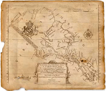
Despite conflicting land claims, settlement in Northern Virginia accelerated at the end of the Susquehannock Wars. By 1673, as Augustine Herrman’s map shows, several permanent, residences had been established along the shores of the Potomac River and its tributaries. By 1690, all waterfront property that today is included within Fort Belvoir had been patented and subdivided.

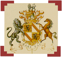
The coat of arm of Thomas, Sixth Lord Fairfax,
became the emblem of the newly created County of Fairfax.
Five major property grants comprised most of the area that today forms Fort Belvoir. In 1694, the 1,000-acre Stoell grant between Accotink and Pohick creeks, plus an additional 150-acre parcel at the mouth of Accotink Creek, were granted to Thomas Ousley (Owsley) of Stafford County. Ousley, who was captain of a local militia group known as the Potomac Rangers, lived on this property and was buried there in 1700. Thus far, archeologists have been unable to locate either Ousley’s grave or the site of his house. By 1718, the McCarty family had acquired the tract, which ultimately was named “Cedar Grove Plantation.”
William Green’s 1669 patent for 1,150 acres encompassed most of what is now Fort Belvoir’s South Post.
Although this property was sub-divided and sold in the early eighteenth century, it was reassembled during the 1730s to create the central portion of William Fairfax’s 2,200-acre plantation of Belvoir Manor.

In 1994, volunteers from Fairfax County’s Heritage Resources
Office search for Thomas Owsley’s seventeenth century home.
The part of Belvoir Neck that borders on Dogue Creek, now the location of the Dogue Creek Village housing complex, was purchased in 1678 by John Wells and Thomas Derrick, who apparently intended the tract as an investment. Portions of their 363-acre grant were subsequently sold to a variety of landowners, including some residents of Maryland. This portion of Belvoir Neck apparently remained a separate parcel until 1918, when it was acquired as part of Camp A.A. Humphreys, as Fort Belvoir was originally called.
In 1671, John Thomas patented 1,000 acres along the upper reaches of Accotink Creek. The exact location is unclear, because the deed describes it only as lying ‘on the head of a creek in Potomac freshes beyond the Doegs Island and land of Col. Speake adjacent land of Robert Lord and James Magregory.” Thomas’ property seems to have included almost all of the area now occupied by Davison Army Airfield, as well as portions of the North Post gold course. By 1718, the same Dennis McCarty who had bought “Cedar Grove” also had purchased Thomas’ property, which he named “Mount Air.”
A 1678 deed conveyed 780 acres of land “on the head of Doug Creek adjacent Mr.Wells and Mr. Thomas” to Colonel William Travers of Essex County, Virginia. In the late eighteenth century, this tract was purchased by George Washington and it becameWoodlawn Plantation. Today, Belvoir’s Commissary, Post Exchange, the Lewis Village housing and the Fort Belvoir Elementary School are all located on this tract.

Agustine Herrman’s 1676 map of Maryland and
Virginia depicted the initial plantations in the southern
portion of Fairfax County in the Belvoir area. |
The largest grant of land—a total of 2,244 acres “between the main run of Accotink and Dogue run, commonly called...Herryford Manor”—was first patented in 1714. A 300-acre section of this large grant, which adjoined Dennis McCarty’s Mount Air property, was sold to the wardens and vestry of Truro Parish for 12,000 pounds of tobacco; this property was known as the Glebe. William Fairfax bought the 300-acre church property in 1752, and added it to his Belvoir Manor Plantation.
By the second quarter of the eighteenth century, population in the region north of the Occoquan River had increased sufficiently to justify the formation of a new political jurisdiction, which was carved out of Prince William County. The new county adopted the cost of arms of the house of Fairfax as its insignia.
| |
Warner’s 1737survey of the Northern Neck proprietary
was the first map to depict the enormous size of the
five million acre grant that extended from the headwaters of
the Potomac River inWest Virginia to the Chesapeake Bay.
|
[ Native Americans
and Europeans
| The Eighteenth Century: Fairfax County's "Golden Age"
]
|
|