USGS logo
Clues from the Past about our Future
Expanding Agriculture and Population
Night Lights and Urbanization
Patterns in Plant Diversity
Baltimore-Washington Urbanization
Great Lakes Landscape Change
Upper Mississippi River Vegetation
Greater Yellowstone Biodiversity
Southwestern US Paleoecology
Palouse Bioregion Land Use History
Northeastern Forest Dynamics

Land Use History of the Colorado Plateau

LUHNA book cover (gif 7K bytes)
The LUHNA Book!

nasalogo.gif (1876 bytes)
Our co-sponsor

Land Use History of North America 
(newnewlogo.gif 4187 bytes)
Table of ContentsLUHNA ProgramProject HistoryContacts
The LUHNA BookFor TeachersLinksContact Us


Historical Landcover Changes in the Great Lakes Region

by


Kenneth L. Cole
Forest and Rangeland Ecosystem Science Center
Colorado Plateau Field Station
Northern Arizona University
PO Box 5614, Bldg. 24
Flagstaff, Arizona 86011-5614
520/556-7466 ext. 230
ken_cole@usgs.gov

Forest Stearns
Rhinelander, Wisconsin

Glenn Guntenspergen
U.S. Geological Survey
Patuxent Wildlife Research Center
11510 American Holly Dr.
Laurel, Maryland 20708
glenn_guntenspergen@usgs.gov

Margaret B. Davis
Department of Ecology, Evolution, and Behavior
University of Minnesota
St. Paul, Minnesota 55108
612/625-5717
mbdavis@ecology.umn.edu

Karen Walker
Department of Ecology, Evolution, and Behavior
University of Minnesota
St. Paul, Minnesota 55108
walke046@.tc.umn.edu


Abstract. Two different methods of reconstructing historical vegetation change, drawing on General Land Office (GLO) surveys and fossil pollen deposits, are demonstrated by using data from the Great Lakes region. Both types of data are incorporated into landscape-scale analyses and presented through geographic information systems. Results from the two methods reinforce each other and allow reconstructions of past landscapes at different time scales. Changes to forests of the Great Lakes region during the last 150 years were far greater than the changes recorded over the preceding 1,000 years. Over the last 150 years, the total amount of forested land in the Great Lakes region declined by over 40%, and much of the remaining forest was converted to early successional forest types as a result of extensive logging. These results demonstrate the utility of using GLO survey data in conjunction with other data sources to reconstruct a generalized "presettlement" condition and assess changes in landcover.

Introduction

The landscapes of the Great Lakes region incorporate dynamic interactions between the grasslands of the Great Plains, the eastern deciduous forests, and the boreal forests of North America. Patterns of climatic circulation give this region remarkably varied climate despite the fairly uniform topography. In the 500 km from southern Lake Michigan to Michigan's upper peninsula, growing season length drops from 180 to 90 days. Natural fire frequency drops from several fires per decade in the tall-grass prairies to several or no fires per 1,000 years in the maple-beech forests of Michigan. The Great Lakes themselves, the largest accumulation of freshwater lakes in the world, create "lake effect" climate zones, with more moderate temperature fluctuations complicating the environmental responses to climate change by interacting with the climate and acting as migration barriers. Urban development in the Great Lakes states is also variable, ranging from dense urban areas such as Chicago to remote wilderness such as Isle Royale and the Boundary Waters Canoe Area. Much of the area has been converted to commercial farmland or forests, but much also remains relatively undisturbed in wildlife reserves, undeveloped wetlands, national forests, and national parks. Documenting the extent and timing of the historical ecological change in such a diverse region presents a scientific challenge.

This chapter demonstrates the use of two different methods of reconstructing the historical vegetation of the Great Lakes region. Nineteenth century survey data are useful for reconstructing the forests that existed at the start of the period of European settlement, when natural ecosystems began to be greatly altered by an industrialized society. But because many impacts may have preceded these surveys and because natural ecosystems often have cyclic or directional natural changes caused by climate, fire, or plant succession, longer-term data are often required in order to place these nineteenth century "presettlement" ecosystems into a larger perspective. We use records of fossil pollen from the Great Lakes region to examine the relationship between this nineteenth century survey data and the vegetation record for the last 1,000 years.


General Land Office Survey Records of the Mid-nineteenth Century

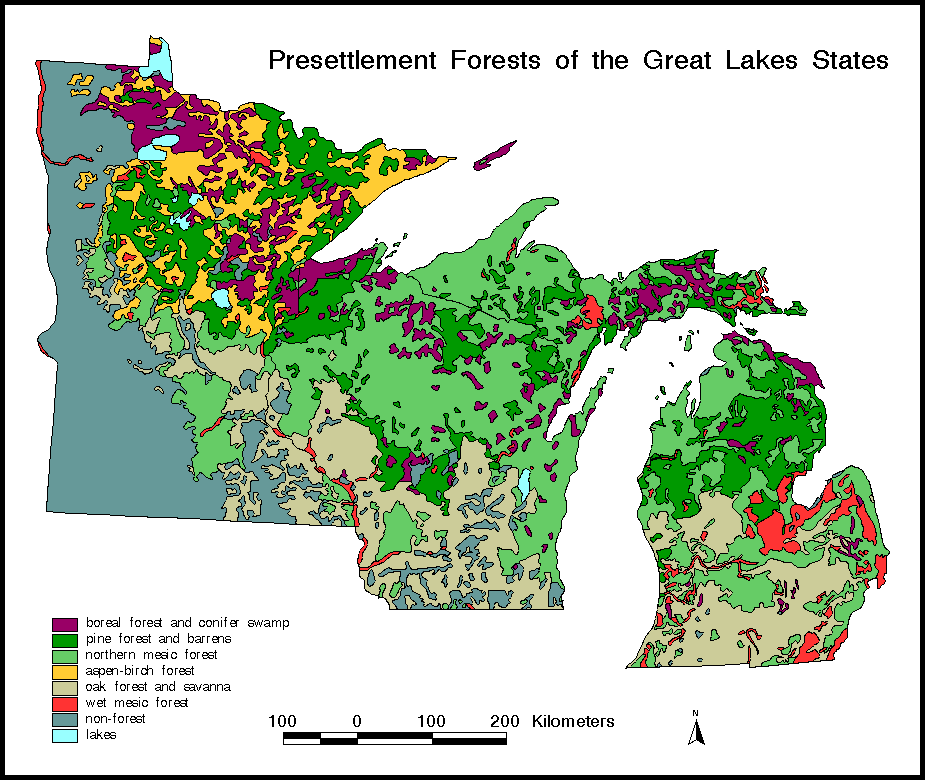
The General Land Office Survey (GLO) of the mid-nineteenth century produced data that can now be used to classify the type of forests that existed at that time (Hutchison 1988). Surveyors delineated township boundaries using "bearing" and "witness" trees. The trees were chosen in a systematic manner, identified by species, recorded in log books, and blazed (marked) to enable relocation of the survey boundaries. Today, 150 years later, the blazed trees are almost all gone, but the data recorded during the survey remain. These data are a valuable record of mid-nineteenth century forests and can be used to develop maps of presettlement forest distribution.

 
Figure 6-1a Map of the presettlement forests of the Great Lakes states in the mid 1800s
Fig. 6-1a. The presettlement forests of the Great Lakes states in the mid-1800's as reconstructed from records of the U.S. General Land Office Survey. Based on Stearns and Guntenspergen (1988).


Figure 6-1b Map of the modern forests of the Great Lakes states 1977 to 1983
Fig. 6-1b. The modern forests of the Great Lakes states (1977 to 1983) as reconstructed from the U.S. Forest Service's Fourth Forest Inventory. Based on Stearns and Guntenspergen (1988).


Figure 6-1c Map of the changes in forest types between presettlement and modern maps.
Fig. 6-1c. Map showing the changes in forest types between presettlement and modern maps.
Using a geographic information system (GIS; Clarke 1997), digitized maps from different time periods can be compared to analyze the changes that have occurred. A digitized vegetation map compiled from GLO maps (Stearns and Guntenspergen 1988; Fig. 6-1a) for the states of Michigan (Veatch 1959), Minnesota (Marschner 1974), and Wisconsin (Finley 1976) was compared with a digitized map of the forests of 1977-83 (Stearns and Guntenspergen 1988; Fig. 6-1b). The GLO surveys were conducted between about 1815 and 1866, and the modern forest map was compiled from the U.S. Forest Service's Fourth Forest Inventory.

Vegetation units on the maps were simplified in order to allow comparison between units used in the modern forest inventory and the three-state presettlement maps. Boreal forests consist mainly of white spruce (Picea glauca), balsam fir (Abies balsamea), and northern white cedar (Thuja occidentalis) and are mapped together with swamp conifer forest of black spruce (P. mariana) and tamarack (Larix laricina). Pine forests are dominated by white pine (Pinus strobus), red pine (P. resinosa), or jack pine (P. banksiana).

Northern mesic forests are mostly mixtures of sugar maple (Acer saccharum), basswood (Tilia americana), yellow birch (Betula alleghaniensis), beech (Fagus grandifolia), and hemlock (Tsuga canadensis) with some oaks. Aspen-birch forests consist primarily of aspen (Populus tremuloides) and paper birch (Betula papyrifera). Oak forest consists of forest and savanna areas of red oak (Quercus rubra), black oak (Q. velutina), white oak (Q. alba), and bur oak (Q. macrocarpa). Wet mesic forests are lowland forests consisting primarily of American elm (Ulmus americana), green and black ash (Fraxinus pennsylvanica and F. nigra), and silver maple (Acer saccharinum). Nonforested areas include prairies, farmlands, and urban areas.

The maps produced for this study represent a broad overview and are generalized in regard to many specific locations and plant communities. Various agencies in all three states are currently producing much more detailed and accurate maps of presettlement and modern landcover classifications using GIS. Future research will allow more thorough mapping of even larger regions.


  Figure 6-2 Graph illustrating the changes in area covered by major forest types in the Great Lakes states between presettlement and modern times.
Fig. 6-2: Changes in area covered by major forest types in the Great Lakes states between presettlement and modern times as calculated from Fig. 6-1c.


  Figure 6-3 Graph illustrating the average size of continuous presettlement and modern forest patches in the Great Lakes states.
Fig. 6-3: The average size of contiguous presettlement and modern forest patches in the Great Lakes states as calculated from Fig. 6-1c.


The presettlement and modern forest maps were overlaid by using a GIS to calculate the extent of area changing from one forest type to another (Fig. 6-1c). Two especially dramatic changes are evident between the maps: the conversion of forest to farmland and the conversion resulting from logging of other forest types to aspen-birch forest. The total amount of forested area declined by over 40%, mostly because of conversion of northern mesic forest and oak forest to farmland in the southern regions of the states. An additional 21% of the presettlement forests, mostly pine in the northern regions, was converted to early successional forests of aspen and birch following logging. Only 39% of the presettlement forests have not changed major type since settlement. Forest types that have declined the most precipitously are pine forest (-78%), boreal forest and conifer swamp (-62%), and northern mesic forest (-61%; Fig. 6-2). The only forest type that has increased is aspen-birch forest (+83%).

The average size of contiguous forests of the same type has also changed (Fig. 6-3). Forest patches (polygons on the map) of pine, oak, and northern mesic forest units are on average less than half of their presettlement sizes. In contrast, aspen-birch forest units and nonforested areas have more than doubled in patch size. These changes in patch size influence the distribution and migration of plant and animal species and may influence other processes, such as fire. However, some of the patch size differences may be caused by the different survey methods used in producing each map. The more detailed and accurate maps currently being produced of the Great Lakes states should be useful in clarifying this issue.

These maps demonstrate that although much of the region is less impacted than other areas to the south and east, extreme environmental changes have occurred in Great Lakes forests over the last 150 years. The severity of these changes can be better appreciated when they are examined in the longer term perspective of the last 1,000 years.


Landcover Changes in the Last 1,000 Years

The Great Lakes states offer uniquely detailed data on historic and paleoecological environments over the last 10,000 years. This pilot project, though, will describe only data covering the most recent 1,000 years. The sediments at the bottom of many lakes are repositories of information on environmental history, containing abundant fossil pollen, diatoms, ostracodes, cladocerans, charcoal, and sediment chemistry. The North American Pollen Database (a public domain database developed by the National Geophysical Data Center) contains data from over 150 sites in the Great Lakes states. An equivalent number of records, many not yet in the public database, have recently been entered into a regional database for Wisconsin and Michigan (M. B. Davis, University of Minnesota, unpublished data). This database greatly extends the detail in the northern portion of these states beyond what was previously available (Webb et al. 1983).


The study of fossil pollen (palynology) from lake and bog sediments is an excellent method for reconstructing past environments (Faegri and Iversen 1989). The fossil pollen is studied by first treating the sediment with a series of chemicals that digest most of the materials in the sediment except the pollen (pollen walls are made of a very resistant material). Then the pollen from the sediment can be identified by using microscopes.

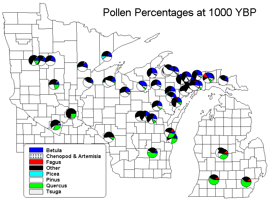
Many pollen samples are taken from a single lake, usually by extracting a core of the lake sediment. Each pollen sample is aged by dating portions of the core with radiocarbon or lead isotopes. Although some studies have produced records as detailed as one sample per decade, this kind of resolution over a 10,000-year period would be prohibitively expensive, requiring the analysis of 1,000 samples. Most sediment cores are sampled less extensively, producing one sample to represent every 50 to 200 years.

Each pollen sample can yield up to 50 different pollen types, each type representing a different plant group. Pollen analysis is especially useful in the eastern deciduous forests of North America because many important tree species produce their own distinctive pollen type. The data can be used to detect past changes at a single site, or multiple sites can be combined to reconstruct past migrations of ecosystems or plant species over the landscape (Davis et al. 1986).

Because of the detailed information in each sample, summarizing the data over a region is difficult, as only the predominant pollen types can be presented. Often, complex statistical analyses are used to reduce the myriad pollen types into indexes representing similar species groups. Some pollen types, such as the goosefoot family (Chenopodiaceae) and the sagebrush group (Artemisia spp.), grow well in recently disturbed areas, such as at the edges of farm fields. These pollen types are excellent indicators of disturbances in ecosystems. Other taxa, such as beech (Fagus grandifolia), grow in old-growth forests that have not been disturbed for centuries.

The abundant fossil pollen records from northern Wisconsin and Michigan provide a record of past forest changes which is extremely detailed. Selected sites were used to compare the modern land cover (1970-90; Fig. 6-4a) with land covers of the presettlement era (1830-60; Fig. 6-4b) and of about 1,000 years ago (Fig. 6-4c). Pollen from sediment cores at each site (represented by pie charts in the figures) furnishes recent and Holocene fossil records, many of which extend back to the retreat of the Pleistocene glaciers about 14,000 years ago (12,000 B.C.) in the south to 11,000 years ago (9,000 B.C.) in the north. Differences between the presettlement and modern surface samples reflect the forest changes occurring between the mid-nineteenth century GLO survey and recent U.S. Forest Service survey (Fig. 6-1c). Although almost all of these samples were taken in undisturbed forested areas, the percentage of disturbance indicators (goosefoot family and sagebrush) increased, especially in the South where much nearby forest was converted to nonforest. In the North, birch usually increased at the expense of white pine as a result of logging. Beech decreased in all but the least disturbed areas.

  Figure 6-4a Surface Sample Pollen Percentages map Fig. 6-4a: Great Lakes states pollen sites showing modern major pollen types measured at the tops of sediment cores in lakes and bogs. Figure 6-4b Presettlement Pollen Percentages map Fig. 6-4b: Great Lakes states pollen sites showing major pollen types just prior to the settlement horizon (about 150 years ago). Figure 6-4c Pollen Percentages at 1000 years before present Fig. 6-4c: Great Lakes states pollen sites showing major pollen types about 1,000 years ago.

Comparison of Changes: 1,000 Years Ago to Presettlement Versus Presettlement to Current

For this chapter, we have contrasted the amount of vegetation change from 1,000 years ago to the presettlement time horizon (a period of about 850 years) with the amount of change taking place between the presettlement horizon and the current era (about 150 years). The data from each pollen record were analyzed by using a statistical method that plots each sample in a multidimensional space using the percentage values for each pollen type in the sample. The distances between the three samples at each site in this multidimensional space (Squared Cord Distance) were then calculated.

The results demonstrate that the average amount of change in pollen types was 2.4 times greater during the 150 years since settlement than during the previous 850 years (Fig. 6-5). This difference is statistically significant (P = 0.0015 for a one-tailed t-test following a log-normal conversion). Recent changes also have a larger range of variability; some sites have changed radically, while others have changed little since settlement. The magnitude of these recent changes can be fully appreciated by considering that no records were taken from cultivated fields or urban areas. Most of the sampling sites were in relatively unimpacted forests which would most likely have been recorded in Fig. 6-1c as "unchanged."

The fossil pollen results support the comparisons of presettlement GLO and modern forest survey data from the first part of this project. The mid-nineteenth century GLO data could not be used to represent general presettlement conditions if forests were changing rapidly throughout the last several hundred years. The results of this pollen analysis suggest that rates of forest change prior to settlement were minor when compared to rates of change after settlement (Cole 1995). As a result, GLO survey data do represent a generalized presettlement condition. More detailed analysis of the fossil pollen demonstrates environmental changes due to fluctuating climate and other factors prior to settlement, but these changes are generally of a much lower magnitude than those occurring since European settlement.

These fossil pollen data are important in providing a regional vegetation history at a resolution unobtainable through any other method. The use of GIS permits the overlaying of digitized data on topography, climate, forest cover, and pollen data, allowing for analysis of past forest changes and its relation to soils, topography, or proximity to the lakes.

The power of this fossil pollen data is that the last several thousand years of environmental history can be examined, providing a more meaningful record of change than the relatively simplistic comparison of presettlement versus postsettlement. Directions and past rates of change can be reconstructed in a dynamic manner investigating past natural changes resulting from shifts in climate, plant migration, and plant succession. These changes can be compared with the recent anthropogenic changes to evaluate the nature and magnitude of change resulting from these very different forces.


Figure 6-5 Scatterplot of the amount of vegetation change between modern and presettlement pollen samples and between 1,000 year old samples and presettlement samples.
Fig. 6-5: Scatterplots of squared cord distance values between modern and presettlement pollen samples and between 1,000-year-old samples and presettlement samples. Box and whisker charts to the right of each scatterplot show the 10th, 25th, 50th, 75th, and 90th percentiles. Open triangles show the 5th and 95th percentiles.


Acknowledgments

The data presented in this chapter were produced through funding from the Western Great Lakes Global Change Research Program of the National Park Service and National  Biological  Service  (now USGS Biological Resources Division). Julie Blackett compiled and analyzed the fossil pollen data, which were produced by many other researchers. Additional assistance was received from the Paleorecords of Global Change Research Training Group (RTG) at the University of Minnesota. Randy Calcote provided statistical assistance, and helpful comments were received from Tom Sisk, Scott Anderson, Daryl McGrath, and anonymous reviewers.


Literature Cited

Clarke, K.L. 1997.
Getting started with geographic information systems. Prentice Hall, New Jersey.

Cole, K.L. 1995.
Vegetation change in national parks. Pages 224-227 in E.T. LaRoe, G.S. Farris, C.E. Puckett, P.D. Doran, and M.J. Mac, editors. Our living resources: a report to the nation on the distribution, abundance, and health of U.S. plants, animals, and ecosystems. National Biological Service, Washington, D.C.

Davis, M.B., K.D. Woods, S.L. Webb, and R.P. Futyma. 1986.
Dispersal versus climate: expansion of Fagus and Tsuga into the Upper Great Lakes region. Vegetatio 67:93-103.

Faegri, K., and J. Iversen. 1989.
Textbook of pollen analysis, 4th edition. John Wiley and Sons, New York.

Finley, R.W. 1976.
The original vegetation of Wisconsin compiled from U.S. General Land Office Survey notes. North Central Forest Experiment Station, U.S. Forest Service, St. Paul, Minnesota.

Hutchison, M. 1988.
A guide to understanding, interpreting, and using the Public Land Survey field notes in Illinois. Natural Areas Journal 8:245-255.

Marschner, F.J. 1974.
The original vegetation of Minnesota compiled from U.S. General Land Office Survey notes. Map, U.S. Department of Agriculture.

Stearns, F., and G. Guntenspergen. 1988.
Presettlement forest of the lake states and major forest types of the lake states: maps. Included within W. E. Shands, editor. Lake states forests: a resources reconnaissance. The Conservation Foundation, Washington, D.C.

Veatch, J.O. 1959.
Presettlement forest in Michigan (map). Department of Resource Development, Michigan State University, East Lansing.

Webb, T. III, E.J. Cushing, and H.E. Wright, Jr. 1983.
Holocene changes in the vegetation of the Midwest. Pages 142-165 in H. E. Wright, Jr., editor. Late quaternary environments of the United States, vol. 2, The Holocene. University of Minnesota Press, Minneapolis.

Next Chapter:
Presettlement and Contemporary Vegetation Patterns
Along Two Navigation Reaches of the Upper Mississippi River

Text-only
Privacy Policy and Disclaimers | Accessibility | FOIA
http://biology.usgs.gov/luhna/chap6.html
Last Updated: Thursday, 20-Nov-2003 15:21:07 MST