 
 The LUHNA Book!
|

  |
|
Along Two Navigation Reaches of the Upper Mississippi River
by
John C. Nelson Lynne DeHaan Larry Robinson
Abstract. Restoration efforts within large floodplain-river ecosystems should rely heavily upon knowledge of these systems prior to large-scale alterations by humans. Unfortunately, most large rivers in the north temperate zone were modified centuries ago--long before any ecological investigations. In many parts of the United States, though, historical records do exist which contain quantifiable data about the "natural" conditions of a region. In this study, we reconstructed presettlement vegetation patterns along two navigation reaches of the upper Mississippi River using data recorded in 1816 by surveyors from the U.S. General Land Office (GLO). Contrary to many previous studies indicating forest as the dominant community type along the floodplains of the upper Mississippi River, our results indicate that prairie was a dominant community type. Savannas, open woodlands, and closed forests were also important features. While flood regime has long been regarded as the master variable influencing productivity and biodiversity within large floodplain-river ecosystems, we propose that fire also played an important role in maintaining some plant communities on the floodplains of the upper Mississippi River.
In 1797, French cartographer Nicolas de Finiels mapped the vast floodplain formed by the confluence of three of North America's greatest rivers: the Mississippi, Missouri, and Illinois. On his map he labeled the floodplain "Grande Prairie," and in his notes he described his view from high atop the Illinois bluffs:
Later, in 1811, a frontiersman named Henry M. Brackenridge described his view of the same confluence region from the bluffs near St. Charles on the Missouri side of the valley:
While historical descriptions such as these are valuable sources of information about former landscapes, they rarely provide sufficient detail to be useful to natural resource managers or restoration planners. Until recently, one of the most useful sources of historical data regarding the unmodified upper Mississippi River ecosystem has largely been overlooked. Survey records of the U.S. General Land Office (GLO) have been used to reconstruct presettlement landscapes and vegetation patterns for many upland regions of the United States, but not for the floodplains along the upper Mississippi River. General Land Office records are particularly useful to ecologists because they contain detailed measurements of presettlement tree composition and timberland structure, as well as maps showing the location and extent of former prairies, swamps, ponds, rivers, streams, marshlands, and timberlands. Unlike historical descriptions, the GLO records provide us with quantifiable data that can be used to reconstruct a baseline condition. Knowing as much as possible about presettlement baseline characteristics of the upper Mississippi River valley is important. At the species level, natural resource managers can use presettlement baselines to formulate management plans on public lands; for example, determining what kinds of trees should be planted on islands. At the community level, a presettlement baseline can identify threatened or endangered ecosystems; for example, by showing whether forests dominated the floodplain or if other plant communities were prevalent. At the landscape level, a presettlement baseline can provide valuable insight into the natural processes that maintain biodiversity; for example, if fire were an important disturbance factor in shaping presettlement vegetation patterns. In this study, we used GLO data to reconstruct presettlement baseline vegetation patterns along navigation reaches 25 and 26 of the upper Mississippi River (Fig. 7-1). Reaches are sections of river between two navigation dams; those along the upper Mississippi River range between 8 and 80 km in length and are numbered consecutively, starting upstream with Reach 1 near Minneapolis, Minnesota, and culminating downstream with Reach 26 near St. Louis, Missouri (total distance 1,072 km). Results of this study provide quantifiable data about the former plant communities native to this part of North America's largest floodplain-river ecosystem. In conjunction with modern data, we discuss some of the plant community changes resulting from European-American settlement of the region over the past 180 years.
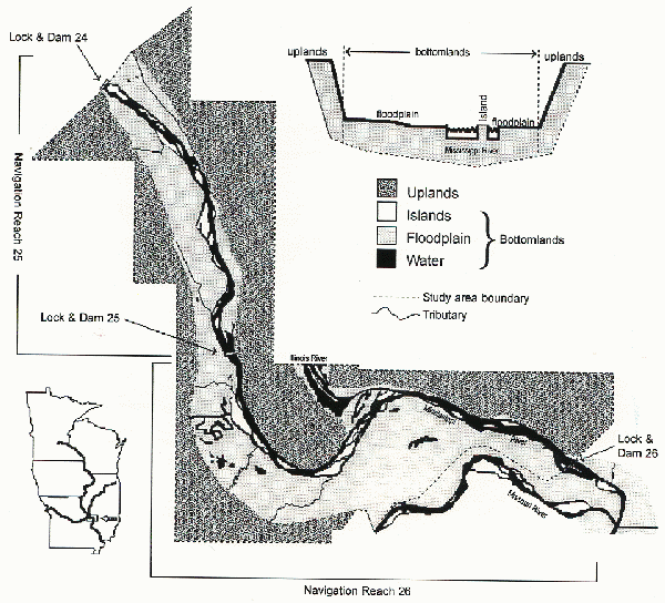
In 1785, the GLO began developing the American Rectangular Survey System to dispense land to settlers in western territories. The new survey system, which still dictates most public land divisions today, divided the landscape into a grid of townships, each 93.2 km2 (36 mi2). Each township was further subdivided into 36 sections, each 2.6 km2 (1 mi2; Fig. 7-2). At each section corner and midway between section corners, GLO surveyors set a post in the ground. In timbered lands, two nearby trees were selected and marked as bearing trees to identify and perpetuate corners. After establishing each corner post, the surveyor recorded the common name and diameter at breast height (dbh) of the bearing trees, along with their distances and compass bearings from the post. If trees were not present, an earthen mound was erected into which the post was set, and "prairie" was written in field notes. Occasionally, only one bearing tree was recorded at a corner, presumably because a second tree was not in close proximity.  In addition to bearing trees, line trees encountered directly on section lines and between corners were similarly recorded. After each surveyed mile, the surveyor noted the type of terrain, soil, undergrowth vegetation, and timber, plus any unusual features. We compiled all these data from microfiche copies of the original GLO field notes obtained from the Missouri Department of Natural Resources and the Illinois State Archives. The GLO completed its initial surveys of the Reaches 25 and 26 study area in 1816. American settlement of the region was preceded by French and Spanish (nearby St. Louis was founded in 1764). The presence of European inhabitants in the decades before the GLO survey negate any real possibility of reconstructing the absolute "pre-European settlement conditions." Since the earlier inhabitants relied mainly on subsistence agriculture and because their numbers were relatively low, however, the GLO records are still one of our best sources of historical data regarding presettlement conditions. Data from surveyors' field notes were compiled according to location among three river valley categories: islands, floodplains, and uplands (see Fig. 7-1 inset). Importance values were then calculated to summarize presettlement tree composition for each river valley category. The numerical importance value for a given tree species can range between 0 and 200 based on two factors, average tree diameter and tree frequency. A tree species can have a higher importance value than other species because it was more frequently recorded by the GLO surveyors or because the diameters recorded were larger than other species. Of course, a species could also have a high importance value due to a combination of both factors. Tree diameter is a good indicator of overall tree size and was used to compute basal area per tree. Dividing the total basal area per species by the total basal area of all species provides an estimate of relative dominance. Relative density is the number of individual trees recorded per species divided by the total number of trees recorded. An importance value for each species was then obtained by adding relative dominance and relative density. Since importance values are based on two sets of relative values, their sum total will always equal 200 (Table 7-1 [separate file]). Tree density for each river valley category was estimated by computing the square root of the mean area per tree (ÖM), which is a function of mean tree distance (Cottam and Curtis 1956). The mathematical computation of tree density using GLO data depends upon the number of bearing trees recorded at each corner. As previously mentioned, most frequently the GLO surveyors recorded two bearing trees, but sometimes only one bearing tree was used, presumably because no other tree was nearby. In some cases though, three and four bearing trees were recorded. Many researchers choose to use only the closest bearing tree distance at each corner to compute the ÖM, and they discard other bearing tree distances. While this method is one way of standardizing the data, valuable information is lost. We incorporated weighted averaging so that all bearing tree distances could be used in the density computation. First, we determined the mean bearing tree distance among corners having either one, two, three, or four bearing trees. Then, we computed the tree density for each of these four groups. The density multiplied by the frequency of corners within each group provided a weighted measure. These weights were summed and then divided by the total sample size to estimate overall tree density. Tree densities were then used to characterize the dominant community type: prairie, savanna, woodland, or forest (Fig. 7-3). A geographic information system (GIS) was used to evaluate landcover changes occurring within the study area since the time of the original surveys (1816). For each township, the GLO produced a plat map delineating the location, size, and shape of any prairies, timberlands, marshlands, ponds, rivers, etc., as well as the arrangement of township and section lines. Since township and section lines are also delineated on modern U.S. Geological Survey (USGS) quadrangle maps, it is possible to make reliable georeferenced GIS landcover maps using GLO plats. Spatial changes in land cover over time were determined by comparing our presettlement map to a GIS landcover map compiled from aerial photographs (bottomlands) and satellite imagery (uplands).

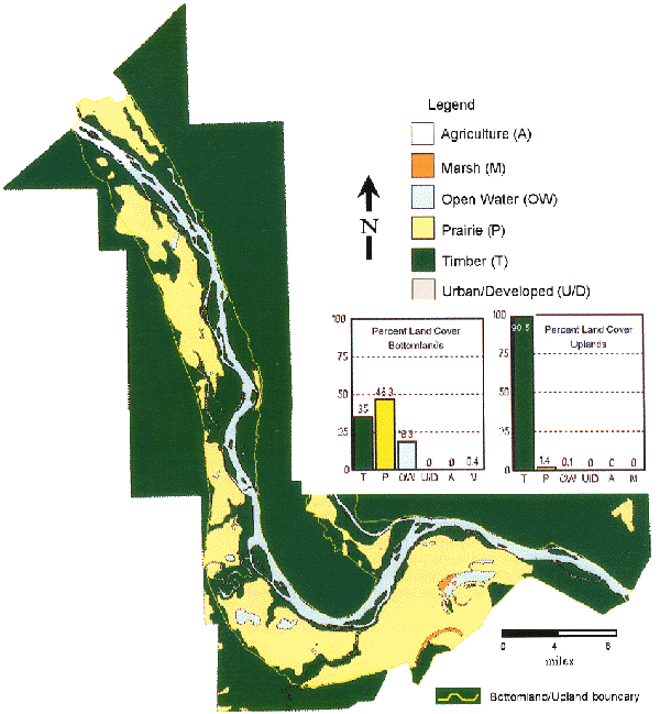
The Presettlement Landscape The presettlement map reveals that prairie was once the dominant community type on the floodplain (Fig. 7-4). Most prairies were vast, covering thousands of acres on the high and intermediate elevations. Often, these large tracts of prairie were separated only by narrow belts of timber growing along tributaries that meandered across the floodplain. Timber was generally restricted to the islands, the banks of the Mississippi River and its tributaries, and the surrounding uplands. These patterns challenge some presettlement vegetation maps of the Midwest that show forest vegetation as the dominant community type along the Mississippi and other large floodplain-river systems (Transeau 1935; Küchler 1964; Anderson 1970). These other presettlement maps, however, use too coarse a scale to reveal the importance of prairie on the floodplains of the upper Mississippi River.
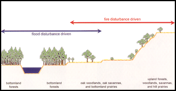
Tree species importance values differed among river valley categories in 1816 (Table 7-1 [separate file]). On islands, where flood disturbance was likely the most frequent, species that produce light seeds dominated. Cottonwood, a pioneer species requiring newly exposed mud flats and full sunlight in order to become established, had the highest importance value at 55. Associated species were hackberry, boxelder, American elm, green ash, and silver maple. Species producing light seeds were also important components on the floodplain, but they were less important than the heavy nut-producing pin oak, which had the highest importance value at 45. Shagbark and shellbark hickory were also important nut-producing trees on the floodplain with a combined importance value of 15. In the presettlement period, oak and hickory communities probably occurred on the better drained soils of higher elevation terraces, which were less prone to flooding. These terraces cover vast regions of the study area on the floodplain away from the main channel of the Mississippi River. The creation of floodplain terraces along the upper Mississippi River can be traced back to the retreat of continental icesheets. During deglaciation, many floodplain terraces were formed by outwash of meltwaters and catastrophic flooding from the outburst of glacial lakes. In the uplands along the river valley, presettlement species composition paralleled the dominants recognized for the Central Hardwood Forest Region, as classified by the Society of American Foresters (Eyre 1980). White oak and black oak were the dominant species with importance values of 76 and 61, respectively. Hickories were important associates with a combined importance value of 23. Ecologists studying presettlement vegetation patterns in the uplands of the Midwest have long attributed the maintenance of prairies, savannas, and woodlands to disturbance by fire. Without fire, grassland communities in the Midwest are invaded by trees and convert to forest. The rate of conversion in the absence of fire can be very rapid, especially for savanna and woodland communities, which characteristically have grassy ground cover and widely spaced trees (Fig. 7-3). When fire disturbance is removed from these communities, new trees can quickly become established, grow up into the overstory, and shade out the grasses and forbs. The disturbance regime that helped maintain a diverse mosaic of communities across upland landscapes is attributed to lightning strikes and annual fires set by Native Americans in the centuries before the arrival of Europeans. According to the GLO data, the Mississippi River floodplain was once covered by prairies with trees growing along the river banks and tributaries. These landscape patterns are similar to those found on many upland sites where prairies covered level to gently rolling terrain and trees grew in areas protected from fire, such as along streams, in ravines, and on hillsides. The dominance of floodplain prairies and the high importance of oak and hickory during the presettlement period may indicate that fires frequently swept across both upland and floodplain landscapes. Many Native American cultures flourished within the upper Mississippi River valley, and they likely extended the burning practices used on surrounding upland landscapes to the floodplain as well. In contrast to fire, flooding presumably played a more important role on islands and on other low elevations near the river channel and its tributaries.
The landscape of the study area has changed considerably over the past 180 years. Prairie was once the dominant community, covering 46.3% of the bottomlands. Today, the prairies have largely been replaced by agricultural fields (Fig. 7-5). While prairies can still be found on some parts of the floodplain (5.6%), the current limited extent of this community and its associated savannas and woodlands should be a primary concern for conservationists. The timberlands that once covered 35.0% of the bottomlands are now reduced to 18.6%. Many of these remaining timberlands lack the diversity of their presettlement counterparts due to past logging, river impoundment, and fire suppression (Nelson et al. 1994; Nelson and Sparks 1998). Tree species diversity is also lacking on many bottomlands because forests are restricted to the most flood-prone areas (islands and river margins) and thus are dominated by flood-tolerant taxa, such as silver maple and ash. Gone are most of the higher elevation oak-hickory woodlands and savannas. Timberlands on the uplands have been reduced from 98.5% to 40.8%. The remaining upland timber occurs on steep terrain along the eastern side of the Mississippi River in Illinois. Since the upland landcover data were obtained from satellite imagery taken in the late 1970's and early 1980's, it is likely that the amount of upland timber occurring now is less than our reported value (40.8%).
 A Conceptual Model The GLO data were also used to help develop a conceptual model of the presettlement river valley ecosystem (Fig. 7-6). Tree composition and tree densities indicate oak savannas and woodlands were once widespread, while plat maps confirm the dominance of prairies on the floodplain. The maintenance of prairies, savannas, and woodlands has long been attributed to frequent disturbance by fire for many upland regions of the Midwest. However, it seems likely that fire also was important for some large floodplain-river ecosystems like the upper Mississippi. Floodplain prairies must have been maintained by some disturbance regime(s), otherwise they would have been overtaken by trees long ago. Conventional wisdom dictates that flood regime was the key factor. However, flood disturbance alone can not explain the maintenance of most floodplain prairies. Degree of flooding is a function of elevation at any given point on the floodplain, and since most of the presettlement prairies occurred on intermediate to high floodplain elevations, they likely often became very dry in late summer and early autumn. Thus, fire was likely the dominant disturbance responsible for maintaining floodplain prairies on these higher elevations. On the generally low elevation sites on islands and along the margins of the Mississippi River, dense forests of cottonwood-elm-maple prevailed. The development and maintenance of this community type occurred on sites subject to frequent flooding, which was probably the dominant disturbance factor on islands and other low-lying areas nearest the river, along side-channels, and along tributaries. Some communities located at intermediate elevations were probably influenced by floods in wet years and fires during dry years. These highly dynamic intermediate zones on the floodplain may have supported savannas and woodlands. In the uplands, as in the high terraces of the floodplain, fire was the principal disturbance factor influencing the maintenance of woodland and savanna communities. Hill prairies that were once extensive along the bluffs of the Mississippi River may have been maintained by fires that originated in the bottomlands and swept up the valley slopes.
The results of this study can be used to help implement ecosystem management plans on Federal lands of the U.S. Army Corps of Engineers and the U.S. Fish and Wildlife Service, as well as in many State-managed conservation areas located along the upper Mississippi River. One goal of ecosystem management should be to recover some of the biological integrity lost by alteration of the landscape during the past 180 years. On the bottomlands, the formerly extensive prairie, savanna, and woodland communities are either nonexistent or have been reduced to small, fragmented patches. Restoration of these communities can be accomplished using prescribed disturbance regimes (fire and flooding) on lands within some Federal wildlife refuges and in some State-managed wildlife areas. Any efforts in the uplands to prevent further forest fragmentation or losses should be encouraged. The remaining hill prairies should be periodically burned to prevent their conversion to closed-canopy forest.
Funding for this project was provided by the Long Term Resource Monitoring Program for the Upper Mississippi River System. The program is supported by the U.S. Army Corps of Engineers and the U.S. Geological Survey, Environmental Management Technical Center (EMTC), Onalaska, Wisconsin. We extend special thanks to Robert J. Cosgriff, Illinois Natural History Survey, for compiling GLO survey notes and Janis Ruhser, EMTC, for georeferencing presettlement landcover data.
Natural and Human Drivers of Biodiversity in the Greater Yellowstone Ecosystem
Text-only |
||||||||||||||