|
|
|||||||||||
| ||||||||||||


|
Haiti
Source: FAO-Forestry. Disclaimer. Version: 2000
Geography and populationHaiti is one of the largest of the Caribbean nations comprising 27 750 km2 of predominantly mountainous land area in the western one-third of the island of Hispaniola. Geographic co-ordinates are: 19° 00'N, 72° 25'W. There are about 1 405 000 ha of agricultural land, which is 50.6% of the total area, and it is estimated that 50% of the land has a slope greater than 40%. There are serious erosion problems, which increase as the lack of alternative economic opportunities leads to expanded cultivation of food crops on steeper slopes higher up in the mountains. For administrative purposes, Haiti is divided into nine departments. One of the distinguishing features of Haiti is that it is a small, densely populated (266.5 persons/km˛) and predominantly rural country. In 1998, about 75% of the population lived under the poverty line. Nearly 70% of all Haitians depend on the agricultural sector, which consists mainly of small-scale subsistence farming and employs about two-thirds of the economically active force. However, the performance of Haiti's agricultural sector has been stagnant. From 1985 to 1989, agriculture's average annual growth rate was -0.5%, continuing the negative trend that began in 1980. However, the 1992, 1993 and 1994 harvests were the highest in recent years due to abundant rainfall and adoption of improved production practices. Economic value of agricultural production has been decreasing, even though land and labour resources allocated to agricultural production have been increasing. Land and labour productivity losses have resulted from a deterioration in the quality of the country's capital stock (e.g., soil fertility, irrigation systems and roads), reflecting a political and economic environment that has discouraged investment. Yields, with the exception of rice, show a negative trend and are becoming increasingly lower than those recorded in other countries of the region. The impossibility for the state to supply much-needed public goods has been the key factor hampering the development of an institutional framework conducive to growth. Climate and water resourcesClimateStrong and irregular rains characterize the tropical humid weather, which are a consequence of the country's mountainous terrain. The average annual precipitation in Haiti is 1461 mm, yet it varies enormously especially with elevation and exposure to the dominant winds. Three areas can be defined:
In the Caribbean, often tropical low pressures can cause depressions, thunderstorms or cyclones depending on the wind speed. On average, there is one cyclone (windspeed over 250 km/h) with devastating effects every five years. The most recent ones have been Gordon, Gilbert and George. In Haiti, temperature changes from one season to the other are minimal. Daily thermal difference (10-12° C), between day and night, is higher than yearly thermal difference between the hottest and the coldest month (3-4° C). As with precipitation, the temperature differs with elevation. In general, temperature drops 1° C per 150-200 m elevation. Water resourcesA detailed survey of the Department of Technical Cooperation for Development of UN in 1991 assessed the water resources of Haiti. The main characteristics are summarized in the following table. In that study, the country was divided into six major basins. Main water resources characteristics summarized by basins in Haiti.
River basins are mentioned as N for north, S for south, E for east, W for west and C for centre. RWR means renewable water resources. WW means water withdrawal. Water supply is given as a percentage of population served. Haiti has 12.11 km3 of internal renewable water resources plus 0.9 km3 of external renewable water resources that come from the Artibonite River from the Dominican Republic. Currently, only about 7.5% of the renewable water resources are utilized, of which 7.1% for irrigation. The rivers' water flow is characterized by wide seasonal fluctuation, partly because of rainfall irregularity, but also because of erosion and deforestation of catchments. Lakes and damsIn 1991, the total installed hydroelectric capacity was 70 MW. The production from hydroplants was 280 GWh/yr, and hydropower amounts for 50% of total electricity production. Irrigation and drainage developmentGiven Haiti's fragile environment and rainfall fluctuations, irrigation has traditionally been an important factor in agricultural development. Although annual rainfall in over 80% of the country's territory surpasses 1 000 mm, the irregularity of rainfall leads to drought periods that prevent use of intensive agricultural practices. Irrigation in Haiti has been priorized in areas with low precipitation and high population density. The most reliable recent information comes from a survey at national level carried out in 1991. The estimation of potential irrigable land was of 143 000 ha. Of these, 91 500 ha were currently equipped for irrigation (Figure 1) and 167 irrigation systems were inventoried: (i) One large scheme (>2 000 ha), located in the Artibonite valley with 35 411 ha of area equipped for full/partial control of irrigation. It was developed mainly for rice production in the 1950 by constructing the Peligre dam and, therefore, controlling the Artibonite River. (ii) Thirty-eight medium-sized schemes (500-2 000 ha) but only five of them are functional at present. In total, they cover an area equipped for full/partial control of irrigation of 39 237 ha. (iii) One hundred and twenty-eight small schemes (<500 ha) with a total of area equipped for full/partial control of irrigation of 16 854 ha. In earlier times, they were considered to be the salvation of Haiti. Later on, however, they have had the same problems as the large and medium-sized schemes: low benefits, lack of maintenance and poor agricultural intensification. Figure 1: Characteristics of the irrigation systems in Haiti in 1991.
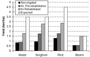
The majority of irrigated land is fed by water diversion systems using a diversion structure and an intake. The remaining irrigated areas are either fed by reservoirs or pumped from underground. Most public irrigation schemes have deteriorated over time because of poor maintenance. Thus, current irrigation investments now concentrate on rehabilitation of existing schemes. Average total costs for rehabilitation of irrigation schemes are from 4 000 US$/ha for medium rehabilitation to 8 000 US$/ha for almost total rehabilitation, depending on the state of the old irrigation scheme. It is expected that rehabilitation efforts should continue in the next future. The main constraints of the present irrigation systems are: (i) Technical constraints. Lack of data for long-time series of precipitation and water resources; inadequate constructions for local extreme conditions (such as cyclones); a high amount of sediments in the rivers and water channels originated from soil erosion; protection against flooding and drainage has not received much attention so far; very high operation and maintenance costs of pumping systems with respect to gravity systems; and lack of maintenance. (ii) Non-technical constraints. The association between land tenure and water rights is not clear, causing negative effects on the operation and maintenance of the irrigation schemes; the management of irrigation schemes and the role of beneficiaries has been underconsidered; the creation of water users' associations and a participatory approach have been negligible so far; and lack of clarity in the legislation and implementation of water fees. Cropping intensity, defined as the number of crops per year, has significantly increased in the 1990s in the gravity rehabilitated projects. The same cannot be said for the pumping systems where water supply is often unavailable because of lack of resources to repair machinery and the unreliability of electricity supply. Yields have also increased during the 1990s in the rehabilitated areas. Nevertheless (i) there are not enough data to accurately determine the impact of irrigation on yield improvement and (ii) the improvement still falls short of the projects' objectives. Measured yields for various non-irrigated crops, irrigated in an old non-rehabilitated scheme and irrigated in a rehabilitated scheme are shown in Figure 2. Figure 2: Selective crop yields (t/ha) under alternative irrigation schemes.
Institutional environmentThe main institutions involved in water resources management are: (a) The Ministry of Public Works, Transport and Communications is responsible for the overall management of the drinking water supply and sanitation sector. Under this Ministry, the Autonomous Metropolitan Drinking Water Company is responsible for services in Port-au-Prince and the National Drinking Water Service (SNAP) for services in the remainder of the country. The Ministry of Health finances and constructs drinking water supply and sanitation facilities in small rural communities. Once completed, these systems are turned over to SNAP for operation and maintenance. (b) The Ministry of Agriculture, Natural Resources and Rural Development (MARNDR) is responsible for the promotion of agriculture, for the conservation and utilization of natural resources, and for rural development. This includes irrigation and drainage. Regional development organizations report to this Ministry. The Directorate of Natural Resources (DRN) operates and maintains all public irrigation systems through the Irrigation and Rural Engineering Service. Most irrigation systems are under the administrative control of the SIGR. However, because of the Ministry's financial constraints, rehabilitation and maintenance operations are taking place under the auspices of other autonomous agencies operating directly with donor support such as the Organization for the Development of the Artibonite Valley and the Organization for the Development of the Gonaives Plain. The Water Resources Service of DRN is primarily concerned with data collection and the Watershed Management Service is responsible for watershed management, including surveying and inventory of soil conservation programmes and assistance to peasants in implementing conservation work at the farm level. (c) Hydroelectricity. The Electricity of Haiti (EdH), an autonomous Government company, is the sole body responsible for electric power generation, transmission and retail distribution in the country. The Minister of Public Works, Transport and Communications acts as the Chairperson of EdH's Board of Directors and sets policy directives; the Board approves major investment plans, borrowing and policies, as well as electricity tariffs. (d) Other water uses. The Ministry of Agriculture, Natural Resources and Rural Development has prime responsibility for protecting natural resources, but conservation policy rests with the Institute for the Safeguard of the National Patrimony, under the Ministry of Education. Main sources of informationDepartment of Technical Cooperation for Development of UN. 1991. République d'Haďti: Programme des Nations Unies pour le Développement: Développement et Gestion des Ressources en Eau. Government of Haiti and Organization of the United Nations, Department of Technical Cooperation for Development, Project number HAI/86/004. 6 vol. New York. FAO. 1995. Haďti: Analyse du secteur agricole et identification de projets. FAO, Investment Centre. Programme of Technical Cooperation. Project number 75/95 TCP-HAI 23 WP. 2 vol. Rome. IFAD-IICA. 1991. Haiti: agricultural sector assessment. International Fund for Agricultural Development and Inter-American Institute for Cooperation and Agriculture. 76 p. Institute Haďtien de Statistique et d'Informatique. 1996. Bulletin special de statistique, 1996, années 1993 et 1994, nombres 164-176. Institut Haďtien de Statistique et d'Informatique, Ministčre de l'Economie et des Finances. Ministčre de l'Agriculture, des Ressources Naturelles et du Développement Rural de la République d'Haďti. 1991. République d'Haďti, politique nationale d'irrigation: ses objectifs et implications. Project number DG/M-A 1083, mémo DRN/DIR/189/90. 2 vol. World Bank. 1991. Haiti: Agricultural sector review. Documents of the World Bank, report number 9357-HA. 69 p. Washington |
|||||||||||||||||||||||||||||||||||||||||||||||||||||||||||||||||||||||||||||||||||||||||||||||||||||||||||||||||||||||||||||||||||||||||||||||||||||||||||||||||||||||||||||||||||||||||
|
||||||||||||||||||||||||||||||||||||||||||||||||||||||||||||||||||||||||||||||||||||||||||||||||||||||||||||||||||||||||||||||||||||||||||||||||||||||||||||||||||||||||||||||||||||||||||


|
|
||
