Photos of the Long Valley Caldera Rim, California
The broad depression of Long Valley Caldera that we see today is much shallower and a little larger in diameter than it was immediately after its formation about 760,000 years ago. Whereas the caldera was floor was initially 2,000-3,000 m deep, now the highest part of the caldera rim is only about 1,000 m above the floor. The caldera was partially filled by pyroclastic flows and tephra during the catastrophic eruption and also by many subsequent episodes of volcanic activity. The original topographic boundary of the caldera walls has been enlarged by landslides, glaciation, and rapid erosion. For example, geologists estimate the modern-day east caldera wall is 3-4 km farther east than its orginal boundary.
View Toward the East Across the Northern part of the Caldera
View is toward the east across the northern part of Long Valley Caldera. The caldera rim extends east from the Glass Creek flow (lower left) to Bald Mountain and Glass Mountain in the far distance. Lookout Mountain is behind the tree.
The volcanic rocks of both Bald Mountain and Glass Mountain were erupted before the caldera-forming eruption. Bald Mountain consists of a lava domes and flows of rhyodacite composition that were erupted between 3 and 2.5 million years ago. Glass Mountain consists of a 1,000 m sequence of lava domes, flows, and welded pyroclastic flows of rhyolite composition that were erupted between 2.1 and 0.8 million years ago.
Lookout Mountain and the Glass Creek flow were erupted after the caldera-forming
eruption. Lookout Mountain is a rhyolite lava flow that was erupted within about
100,000 years of the caldera-forming eruption. Glass Creek flow was erupted
about 600 years ago during the Inyo
eruptions.
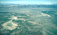
View Toward the Northeast rim of the Long Valley Caldera
Aerial view is toward the northeast rim of Long Valley Caldera from above the resurgent dome (forested area in lower left). The Owens River flows from left to right between the dome and caldera rim in the broad depression known as Long Valley, after which the caldera was named.
The surface of the flat lowlands east of the resurgent dome is layered with sediments that were deposited when a large lake filled the caldera. Scientists have identified terraces and standlines from the former lake both along the eastern caldera wall and on the flanks of the resurgent dome. During the early life of the lake, glaciers flowing into it from the Sierra Nevada generated icebergs that drifted across the lake. The icebergs carried large granite rocks eroded from the Sierra Nevada and deposited them on the flanks of the resurgent dome, which stood as an island, and on the lake terraces on the east caldera wall.


