The project site is located along Bergerville Road 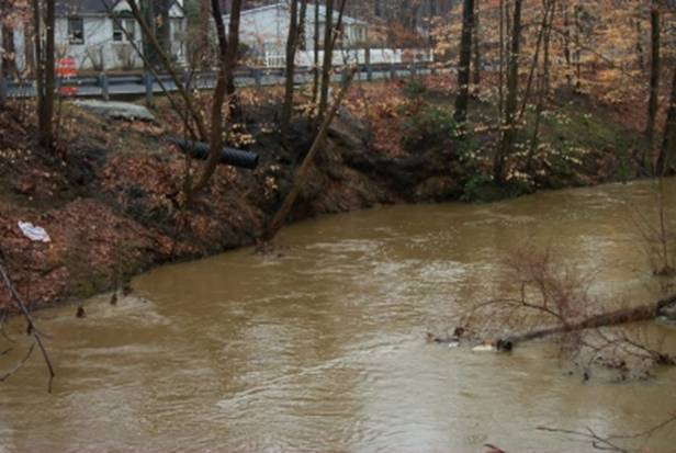
(a.k.a. Casino Road) in Howell Township, Monmouth County, New Jersey. Approximately, 500 feet west of the project site, Casino Drive becomes Bergerville Road as it crosses into Freehold Township. The road is owned and maintained by Howell Township, who has requested the assistance of the U.S. Army Corps of Engineers (USACE) in alleviating damage to the road by flooding and erosion resulting from encroachment of the Manasquan River. Howell Township is the non-Federal sponsor of this activity.
At the project site, Bergerville Road is approximately eight to twelve feet from the south bank of the Manasquan River at a point where the river makes a U-shaped bend. The river is somewhat downcut at this location, with floodplain wetlands located inside the meander bend and residential properties located on a low terrace just outside the meander to the north. During high flow periods, water is directed into this bend at sufficient velocity to undercut the south bank. Further up the bank, above the area being undercut, additional erosion is resulting from bank slumping. Bergerville Road has been repaired several times in the past few years after being damaged by bank slumping. The bank in this area is approximately 26 feet high. Approximately 250 linear feet of stream bank requires some form of stabilization and erosion control to protect Bergerville Road.
Bergerville Road is classified in Howell Township's Master Plan as a Collector Road with a recommended ROW width of 66'. The current ROW width is 60' and has an average pavement width of 40'. Bergerville Road connects Howell Township with Freehold Township. It serves as the only entranceway into the Pointe 0 Woods development which contains 344 condos, 209 townhouses and 172 single-family dwellings for a total of 725 units. It also serves a senior development in Freehold Township and may be the quickest emergency access to these areas off of Route 9.
A full range of alternatives was developed and coordinated with Howell Township, USACE, the New Jersey Department of Environmental Protection (NJDEP), the U.S. Fish and Wildlife Service, and others. These alternatives fall into the following categories: bioengineering and other soft engineering techniques, engineered structures, stream relocation, road relocation combined with stream bank stabilization, and retaining walls.
A multi-objective planning process for this project has been done where economic, social, and environmental considerations were taken into account. During the formulation process, several of the alternatives were selected that alleviated the identified problems at Bergerville Road in ways that were consistent with both Federal objectives and the desires of the community. The full range of reasonable alternatives was considered during the National Environmental Policy Act (NEPA) process, resulting in the systematic elimination of alternatives that did not meet the purpose of and need for the action. The alternative plan that best met the environmental and technical criteria for this project site was selected as the proposed action.
The proposed action for this project is a Cellular Containment System (CCS). A CCS wall consisting of a three-dimensional honeycomb structure made of polyethylene would be constructed along the steeply sloping bank. CCS walls are less expensive and more aesthetically pleasing than the other alternatives considered. While cells in the lower portions of the CCS wall would be filled with concrete to protect the lower banks, cells on the upper portions of the bank would be filled with soil and then vegetated. This vegetation could lead to improved riparian habitat on the riverbank. Construction impacts would be similar to those from sheet piling or modular block walls. Construction of the CCS wall would involve moving the centerline of the stream approximately 10 feet away from the existing right bank to provide a stable foundation and slope for the wall. The configuration would shift the river to an historical alignment that currently consists of a gravel point bar and riparian wetlands. This adjustment is expected to cause fewer environmental affects than other proposed alternatives; in addition, hydrologic modeling indicates that stage heights would be reduced because the modified channel would have greater capacity. Utilities would not have to be moved nor real estate condemned as in the road relocation alternative. Although construction impacts, the need to anchor the wall into the stream bottom, and the need for a drainage system are similar to the other types of retaining walls, the CCS wall allows for more natural stream substrates, bank slopes, riparian vegetation, and aesthetics. The project life span for the CCS wall is expected to be greater than 50 years with total project costs around $1.5 million.
|


