Water Supply Menu


The Fildami open-air reservoir

back 1 .. 2 .. 3 .. 4 .. 5 .. 6

 
Aerial View 
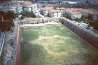
For the final three days of the project we conducted survey at the Fildami open-air reservoir near Bakirkoy. Dr Tülay Egil of Istanbul Archaeological Museum carried out the only previous study of this structure in 1968 while overseeing the removal of the earth obscuring the east face of the structure (Firatli, 1969, 192; Ergil, 1974).

Plan of Fildami

Plan and elevations of the Fildami reservoir, produced using a Leica TCR307 Reflectorless Total Station

A comprehensive photographic record was produced and marked with control points which were then surveyed, thus providing us with an archive from which detailed elevation drawings of each façade can be produced using rectified photographic processing.

exterior elevation

interior elevation


Fildami TowerWe also undertook a detailed investigation of the piezometric tower in order to determine its functionality and a series of plans and sections were produced. GPS control points were established and the structure was tied into our master survey grid of Thrace.


back 1 .. 2 .. 3 .. 4 .. 5 .. 6


2000 Report Index

The Anastasian Wall
• Southern Sector
the Büyük Bedesten
The Aqueduct System
Reconnaissance
• the Fildami Reservoir
Acknowledgements


ARCHAEOLOGICAL HINTERLAND OF CONSTANTINOPLE - FIELDWORK REPORTS
site design and maintenance by Richard Bayliss
home page project acknowledgements Fieldwork Photo Album Project Bibliography Reports from 1994 onwards 3d visualisation of the water supply system Fieldwork Methodology Geology, Hydogeology and the Water Supply of Constantinople Channels and Aqueducts from the springs around Halkali Channels and Aqueducts in the Forest of Belgrade Water Supply and Distribution in Constantinople Major Water Bridges on the Aqueduct System The Longest Roman Aqueduct Go To Anastasian Wall Pages Intoduction to the Water Supply Project historical overview of the development Contantinople's water supply Dynamic Navigation Map