
|
|

 Activity
Mauna Loa |
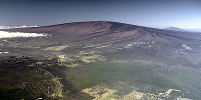 Photograph by J.D. Griggs on January 10, 1985 |
Rising gradually to more than 4 km above sea level, Mauna Loa is the largest volcano on our planet. Its long submarine flanks descend to the sea floor an additional 5 km, and the sea floor in turn is depressed by Mauna Loa's great mass another 8 km. This makes the volcano's summit about 17 km (56,000 ft) above its base! The enormous volcano covers half of the Island of Hawai`i and by itself amounts to about 85 percent of all the other Hawaiian Islands combined.
Mauna Loa is among Earth's most active volcanoes, having erupted 33 times since its first well-documented historical eruption in 1843. Its most recent eruption was in 1984. Mauna Loa is certain to erupt again, and we carefully monitor the volcano for signs of unrest. See current activity for a summary of our monitoring efforts.
Hawaiian Meaning
The Hawaiian name "Mauna Loa" means "Long Mountain." This name is
apt, for the subaerial part of Mauna Loa extends for about 120 km
from the southern tip of the island to the summit caldera and then
east-northeast to the coastline near Hilo.
Mauna Loa Facts
Map of the Island of Hawai`i
|
Location 19.475 N 155.608 W
Elev. Above Sea Level
Area
Volume |

Most Recent Eruption
March 24-April 15, 1984
Number of Historical Eruptions
33
Summit Caldera
Name: Moku`aweoweo, "Moku" refers to a coastal land section or
islet; "`aweoweo" is a type of red Hawaiian fish. Literal translation
is fish section (the red of the fish suggests red lava).
- Dimension: 3 x 5 km, elongated northeast-southwest
- Depth: 183 m deep
- Age: estimated to have collapsed 600-750 years ago
Between 100,000 and 200,000 years ago
Estimated Age of Earliest Subaerial Eruptions
About 400,000 years ago
Estimated Age of First Eruption of Mauna Loa
Between 1,000,000 and 700,000 years before present
Hawaiian Volcano Stage
Shield-forming stage
![]()
![]()
![]()
![]()
![]()
![]()

![]()
![]()
![]()
![]()
Contact: hvowebmaster@usgs.gov
Updated: 2 February, 2006 (pnf)