The Bathymetry and Sediments
of Wallowa Lake,
Northeast Oregon
Bryce Budlong,
J.R. Collier, Calvin Davis, David E. Gilbert, Rob Ledgerwood, and
Jay Van Tassell
Science
Department- Badgley Hall, Eastern Oregon University,
La Grande, OR
97850-2899
ABSTRACT
Bathymetric profiling of Wallowa
Lake shows that the two sub-basins that make up the lake floor have been filled
with sediment deposited as the glaciers retreated and by sediment washed in
from the Wallowa River across the delta at the south end of the lake.Ā In many areas, the lake floor slopes gently
toward the west. There are two west-northwest-trending underwater moraines
between the two sub-basins that have reliefs of up to 20 ft (6m) and can be
traced out of the water into subtle north-sloping topographic benches on the
late Wisconsin glacial moraines on the
lake.Ā The southern sub-basin floor is
cut by two faults that trend at N60E across the lake floor.Ā The faults form the borders of an ~0.3 mi
(0.5 km) wide flat-floored valley (graben) in the deepest part of the south
basin.Ā
Sand and gravel were found in
depths up to 132 feet (40 m).Ā Below this
depth, much of the lake floor is covered with mud that is rich in diatoms,
sponge spicules, conifer pollen, and organic material.Ā This mud is frequently laminated (varved?) or
mottled, is overlain by sand in some areas near the lake margins, and is
underlain in the area between the two underwater moraines by a layer of silt
and mud that lacks diatoms.ĀĀ
INTRODUCTION
Wallowa Lake
is a world-class example of a glacial lake dammed by moraines.Ā The spectacular moraines around Wallowa Lake rise to 275 m (900 ft) above the
lake, and their bases are hidden beneath the lake, which has a maximum depth of
86 m (283 ft; Phillips and others, 1965, p. 65).Ā At the peak of the last ice age, nine large
glaciers and their tributaries, plus several other isolated ice fields and
glaciers, covered a total of ~337 square miles of the Wallowa
Mountains (Fig. 1.)Ā The
glacier that occupied the west fork of the Wallowa River
was 21 km (13 mi) long and the one that occupied the east fork was 8.9 km (5.5
mi) long.Ā The Wallowa glacier was
thickest at its junction with the East Fork (460 m; ~1500 feet) and its
terminus reached an elevation of 1280 m (4200 ft; Allen, 1975).
ĀĀĀĀĀĀĀĀĀĀĀ The Wallowa River
debouched from the canyon onto a large alluvial fan prior to deposition of the Wallowa Lake moraine (Bentley, 1972.)Ā Then, the moraine was built up in a series of
stages as glaciers advanced northward and retreated southward.
The moraine complex on the east side of Wallowa Lake
includes more than a dozen individual moraine crests and the west moraine has
about half a dozen (Carson, 2001).Ā The
complexity of the west moraine complex may be because the ice from the east
fork

Figure
1.Ā Extent of glaciers in the Wallowa Mountains at the peak of the last glaciation
(Allen, 1975, Orr and others, 1992).
cascaded down onto the ice in the west fork, distributing
the material over the valley rather than concentrating it.Ā This caused an increased accumulation of
debris on the east side of the glacier which would have been deposited on the
eastern margin of the ice as melting occurred, causing the toe of the glacier
to be deflected progressively toward the west with each advance of the ice and
leaving the more complex moraine now visible on the east side of Wallowa Lake
(Stovall, 1929, p. 70; Bentley, 1972).
ĀĀĀĀĀĀĀĀĀĀĀ The number
of glacial advances that built the Wallowa
Lake moraine complex
remains controversial.Ā The compound nature
of the moraines bordering Wallowa Lake was first recognized by Stovall (1929),
who recognized 8 lateral moraines on the east side of Wallowa Lake and divided
these into two groups: 1) an older group of moraines that lack boulders of
granodiorite at their surfaces and have subdued morainal topography, and 2)
younger moraines which are strewn with granodiorite boulders and have more
pronounced morainal topography.Ā Only two
episodes of glaciation were recognized by Stovall (1929) and Lowell (1939), while
Burke (1980) concluded that there are three ages of tills present in the area
and Crandell (1967), who carefully studied the boulders and soils of the Wallowa Lake
moraines, concluded that there were 4 episodes of glaciation recorded by the
moraines at Wallowa
Lake (Fig. 2).Ā The youngest unit recognized by Crandell
(1967), Drift Unit W, includes two terminal moraines at the north end of
Wallowa Lake, lateral moraines bounding both sides of the lake, an
inconspicuous north-sloping lateral moraine that descends the embankment of the
east moraine about a mile from the south end of the lake, and a small
recessional moraine about a mile further upriver from the lake.

Figure 2.Ā Crandell's (1967) map of the Wallowa Lake
moraines plus the bathymetry of Wallowa
Lake from the Atlas of
Oregon Lakes (Johnson and others, 1985).Ā
The moraines, from oldest to youngest, are:Ā C, J, T, and W.Ā Dashed lines indicate moraine crests.
The ages of the Wallowa Lake
moraines, based on correlation with other glacial sequences in the Rocky
Mountains, Sierra Nevada, and Western Washington areas, have been estimated
atĀ ~25,000 to 10,000 years ago and ~
300,000 to 150,000 years ago (Crandell, 1967) and between ~600,000 to 300,000 years
ago (Sibrava and others, 1986).ĀĀ One
exciting new development is the dating of boulders on the two younger drift
units using high-resolution cosmogenic 10Be chronology by Licciardi
and others (2004).Ā This dating suggests
that the second oldest advance is ~ 21,000 years, instead of ~300,000 years old
as Crandell (1967) thought, and that the youngest advance is ~17,000 years
old.Ā The dates revealed that some of the
Wallowa Lake moraines are composite features
formed during both glacial episodes.ĀĀ
This new evidence suggests that the two older glacial advances may be
much younger (300,000 to 150,000 years old?) than earlier thought.Ā This would make the glacial chronology
recorded at Wallowa
Lake similar to that
documented in neighboring mountains such as the Elkhorns.Ā We won't know for sure until age dating of
the older moraines becomes available.
After the last glacial advance ~17,000 years ago, the
Wallowa glacier retreated uphill to the area of the Glacier Lake cirque, where
there is evidence of a series of younger glacial advances that did not reach
the Wallowa Lake area.Ā The oldest of
these advances is the Glacier
Lake advance, which has
been dated at ~11,000-10,000 years before present by Licciardi and others
(2004) using high resolution cosmogenic 10Be analysis
techniques.ĀĀ Later glacial advances that
were confined to the cirques in the Wallowa Mountains have been dated at
~2,600-4,500 years before present (Williams, 1974), between ~175-875 A.D., and
between ~1600-1875 A.D. (Kiver, 1974; also see Burke, 1978, and Burke and
Birkeland, 1983) based on the diameters of the lichens growing on the boulders
in the moraines.Ā Glaciers were reported
in the Wallowa Mountains by Smith (1918),
Stovall (1929), and Stadter (1931).Ā W.D.
Smith and others (1941, p. 36) reported that in 1940 "the last small
glacier existing in the Wallowa Mountains is located in a depression on the
ridge at the head of Glacier
Lake cirque..." The
Atlas of Mountain Glaciers (1958) also shows a glacier in this position.Ā By 1972, as Bentley (1974, p. 68-69)
reported, "one would be hard-pressed to identify a "glacier" in
the Wallowa Mountains."Ā
The Lostine
Valley to the west of Wallowa Lake
was occupied by a glacier that was 35 km (22 mi) long, the largest in the Wallowa Mountains (Fig. 1).Ā It originated near Eagle Cap (elevation 2925
m; 9,595 ft) in the center of the Wallowas and descended to an elevation of
1030 m (3,380 ft; Allen, 1975).Ā The road
along the Lostine
Valley crosses a series
of end moraines deposited as the glacier retreated up the valley as the glacier
retreated.Ā Is it possible that as the
Wallowa Glacier retreated similar moraines were left behind on the floor of the
Wallowa Lake and were then submerged as the lake
level rose?
BATHYMETRY OF WALLOWA
LAKE
One piece of evidence supporting
the hypothesis that there are submerged glacial moraines on the floor of Wallowa Lake is the inconspicuous north-sloping
lateral moraine that descends the east moraine embankment about a mile from the
south end of the lake that was mapped by Crandell (1967).Ā The bathymetric chart of the lake prepared by
researchers from Portland State University (Johnson and others, 1985) shows
that the lake is divided into two sub-basins separated by a ridge which could
possibly be a moraine, but the chart is not detailed enough to answer this
question for sure (Fig. 2).Ā
ĀĀĀĀĀĀĀĀĀĀĀ Our survey
of the floor of Wallowa
Lake was made with an
Odom Hydrotrac precision depth sounder, which is accurate to ~1 foot when
properly calibrated, with a paper chart recorder and built-in Starlink GPS
receiver (Fig. 3).ĀĀ A hand-held Garmin
GPS receiver was used when the Starlink GPS did not work properly.Ā We ran a total of 24 depth-sounding profiles
up and down and across Wallowa Lake in July and August 2002 and collected
additional profiles during the summers of 2003 and 2004 (Fig. 4,5).


Figure 3.Ā Setting up the depth sounder and GPS antenna
on board the research vessel (top) and close-up view of our Odom Hydrotrac
depth sounder during profiling (bottom).Ā
Photos by David Gilbert.
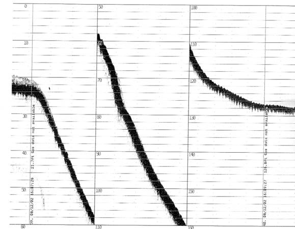
Figure 4.Ā Example of a depth sounding record from Wallowa Lake.Ā
The chart recorder automatically changes scale when the depth reaches
the bottom of the paper.Ā A fish is
visible at a depth of 16.5 feet on the left hand side of the profile.Ā The wavy pattern on the right hand side of
the profile is due to waves rocking the boat at the surface.
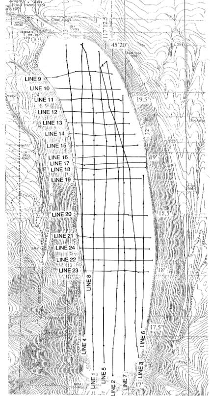
Figure
5.Ā Chart showing the tracks of our
bathymetric survey lines.
The results of our bathymetric
profiling of Wallowa
Lake, digitized and
contoured using the geographic information systems (GIS) programs MapInfo and
Vertical Mapper, confirm that the lake floor is divided into two sub-basins
(Fig. 6).Ā The east-west profiles across Wallowa Lake clearly show the steep sides of the
glacial moraines and reveal that the lake floor is not a simple glacial
u-shaped valley (Fig. 7).Ā It has been
filled with sediment as the glaciers retreated and by sediment washed in from
the Wallowa River across the delta at the south end
of the lake.Ā In the southern part of the
northern sub-basin, the east-west profiles show low-relief ridges and sharp
peaks on the bottom of the lake.Ā In many
areas, the lake floor slopes gently toward the west.

Figure 6.Ā Bathymetric chart of the floor of Wallowa Lake.
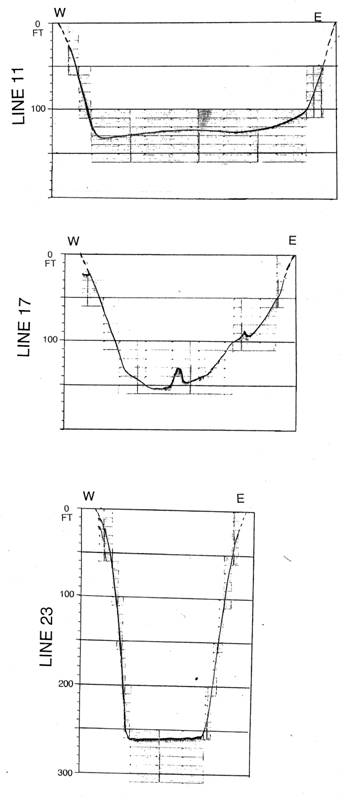
Figure 7.Ā Representative west to east direction
bathymetric profiles across the north (top), central, and south (bottom) parts
of Wallowa Lake.Ā
Profile locations are shown in Figure 5.
ĀĀĀĀĀĀĀĀĀĀĀ The
north-south profiles along the length of the lake reveal two west-northwest-trending
underwater ridges between the two sub-basins discovered by Portland State
researchers (Fig. 8).Ā Each ridge has a
relief of up to 6 m (20 ft) and is a compound feature covered with large
boulders (glacial erratics).Ā The ridges
show up clearly on the bathymetric chart on the east side of the lake but are
less defined on the west side of the lake, where they appear to have been
eroded away, possibly by glacial meltwater streams flowing along the west side
of the lake basin.Ā Each ridge can be
traced out of the water into subtle north-sloping topographic benches on the
youngest glacial moraines on the lake margin.Ā
One of these topographic benches is the inconspicuous lateral moraine
described by Crandell (1967).Ā This
evidence suggests that the two underwater ridges are glacial moraines deposited
sometime after the ~17,000 year old moraines at Wallowa
Lake and before the ~10,000 year old Glacier Lake moraines.Ā They may have formed during a glacial advance
or could be recessional moraines formed as the ice retreated.

Fig. 8.Ā Bathymetric profile in a south to north
direction across the floor of Wallowa
Lake.Ā
One surprise revealed by the depth
sounding of Wallowa Lake was the discovery of two faults that trend N60E at
an acute angle to the main trend of the Wallowa Fault along the base of the
mountains and the faults mapped by Walker (1979)
in the Wallowa Lake area (Fig. 9).Ā The fault zones are commonly marked by
shallow depressions on the depth sounding profiles.Ā This suggests that the faults may be active;
otherwise they would tend to be filled with sediment.ĀĀ The faults can be traced from profile to
profile across the lake floor and form the borders of an ~ 0.5 km wide flat-floored
valley (graben) in the deepest part of the south basin.Ā There is no sign of the faults cross-cutting
the moraines on the east side of the lake but the topography on the west side
of the lake and on the northeast flanks of Chief Joseph Mountain sloping down
toward the lake shows irregularities that may be related to the faulting.ĀĀ
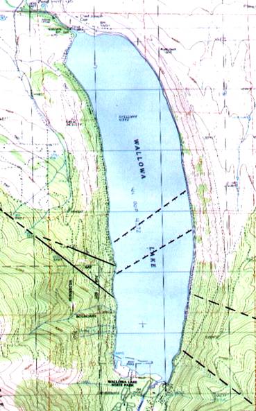
Figure 9.Ā The trends of the two faults mapped on the
bottom of Wallowa Lake in comparison with the trend of faults mapped
along the shores of Wallowa Lake by Walker
(1979).
SEDIMENTS
ĀĀĀĀĀĀĀĀĀĀĀ The sediments
in Wallowa Lake have been described as
"relatively coarse" (Johnson and others, 1985, p. 140), probably
because sand, gravel, and boulders (glacial erratics) are exposed at the
shallow north and south ends of the lake and along the lake margins when the
lake level is low.Ā Larson (1981, p. 104)
stated: "The bottom of Wallowa Lake is covered predominantly in barren
sands and gravels, in contact with low temperature water (near 4˚C in
summer), and is overlain by 60-80 m of water which effectively keeps the bottom
in darkness by filtering incident solar radiation.Ā In general, the lake's bottom represents a
biologically unfavorable benthic habitat.Ā
In the limnetic or open-water zone, seemingly small supplies of
inorganic nutrients...generally restrict the abundance of phytoplankton.Ā As primary energy-fixing organisms in the
aquatic food-chain, phytoplankton ultimately determine the growth, production,
and survival of crustaceans, insects, fish, and other consumer
organisms."Ā The results of plankton
tows in Wallowa Lake in 1973 show that the algae Dinobryon divergens
accounted for 60 to nearly 100 percent of the phytoplankton biomass.Ā Other phytoplankton sampled included Mallomonas
producta, Ceratium hirundinella, and the diatoms Aulacoseira
(Melosira) italica and Fragillaria crotonensis.
Our studies have confirmed that the
sediments in the shallow portions of Wallowa
Lake are
coarse-grained.Ā Large boulders (glacial
erratics) were apparent on our depth sounding profiles in the north end of the
lake. ĀProfiling with a side-scan
transponder attached to our depth sounder during the summer of 2003 revealed
abundant dead trees around the margins of the lake, particularly on the lake's
west shore.Ā
ĀĀĀĀĀĀĀĀĀĀĀ Are the
sediments in the deeper parts of the lake coarse-grained, too?Ā We attempted to sample the lake floor
sediments in August 2002 using a small pipe dredge.Ā The sediment collected during this survey
from the lake bottom within the graben consists of silt with abundant wood
fragments, which may have been deposited by the July 18, 2002 flash flood that
diverted the Wallowa
River and filled the lake
with debris (Budlong and others, 2003).Ā
We managed to recover some sand samples from the lake margins with the
pipe dredge, but encountered problems with the samples washing out when we
attempted to sample the deeper portions of the lake floor.
ĀĀĀĀĀĀĀĀĀĀĀ We returned
to the lake in the summer ofĀ 2004 with a
Wildco Ballchek gravity corer, which has a ball at the top that seals the corer
and creates a suction when the corer is lifted from the bottom, creating a
suction that helps keep the core in the core barrel.Ā Using a hand-powered Wildco winch, we lowered
the corer and let it freefall to the lake bottom.Ā Then the corer was winched back to the boat
and the sample was extruded using a pipe with a cork on one end, which acted as
a piston.Ā Samples that were cohesive
enough to maintain their shape were split longitudinally with a knife (Fig.
10).Ā All samples except the final core,
which was preserved intact in a plastic core liner, were described on board the
boat and then returned to the laboratory for detailed analysis.Ā Smear slides were made from samples taken at
5 cm intervals from each core and examined at 400x power using a Leitz Laborlux
Pol petrographic microscope.
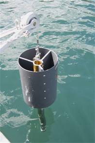
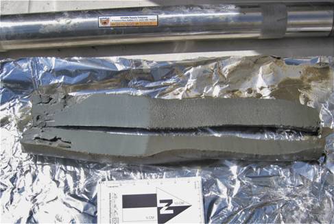
Figure 10.Ā Lowering the Wildco Ballchek gravity corer
into Wallowa Lake (top) and an example of the one of
the cores (bottom).Ā The top of the split
core (bottom photo) is to the right.Ā
Note the distinctive laminated (varved?) gray mud on the bottom of the
core and the brown silty mud overlying the gray mud.Ā A small amount of unconsolidated sand is
visible on the top of the core on the right hand side of the photo).Ā The brown color changed to gray when the core
dried.Ā Photos by David Gilbert.
The analysis of the cores from Wallowa Lake (Fig. 11) confirmed that the
sediments in the deeper portions of the lake are much finer-grained than
previously believed (Fig. 12).Ā Sand and
gravel were found in depths up to 132 feet.Ā
Below this depth, much of the lake floor is covered with mud that is
rich in diatoms, sponge spicules, conifer pollen, and organic material.Ā These muds are frequently laminated (varved)
or mottled.Ā The most common diatoms
present in the lake floor muds are Aulacoseira (Melosira).Ā Other common diatoms include Asterionella,
Cocconeis(?), Cyclotella, Cymbella, Diploneis, Epithemia, Fragillaria,
Gyrosigma, Navicula, Nitzchia, Stephanodiscus, Synedra, and
Tabellaria.Ā This suite of diatoms indicates
deep-water conditions and is similar to that found in the modern Columbia and Snake
Rivers.Ā Conifer pollen in the cores included Tsuga
(hemlock), Picea (spruce), and Pinus (pine).Ā The freshwater sponge Ephydatia
fluviatilis was the most common sponge spicule in the lake sediments.

Figure 11.Ā Location of the cores collected from the
floor of Wallowa Lake and the type of sediment present at
the top of the core.Ā S:Ā Sand.Ā
M:Ā Mud.Ā NR:Ā No
recovery.
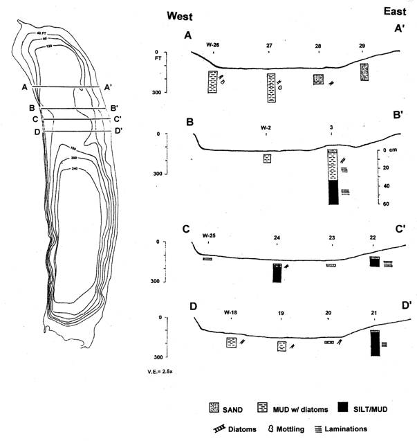
Figure 12.Ā Cross-sections through the northern sub-basin of Wallowa Lake illustrating the types of
sediments present in the cores.
The coring revealed that sand
overlies the diatom-rich muds in the northern sub-basin of Wallowa Lake
north of the northern underwater moraine (Fig. 12). ĀThe stratigraphy in the area between the two
underwater moraines in the northern sub-basin is more complex.Ā On the western side of this area, the sand on
the lake floor is underlain by diatom-rich mud that is underlain by a layer of
fine-grained silt and mud that lacks diatoms.Ā
On the eastern side of the area between the two underwater moraines, the
layer that lacks diatoms directly underlies sand without the intervening
diatom-rich mud layer.Ā This sequence of
1) fine-grained mud and silt overlain by 2) laminated (varved) and mottled
diatom-rich mud, and 3) sand and coarser sediments suggests that conditions of
deposition have changed through time.Ā
Lake sedimentation in regions where
the lake and rivers flowing into the lake freeze during the winter is often
characterized by a seasonal, rhythmically laminated (varved) depositional
regime in which the input of sediment into the lake is cut off and dark,
clay-rich layers are deposited from suspension after the winter overturn when
clay that has been caught in the thermocline due to the seasonal stratification
of the lake is released and settles to the bottom.ĀĀ During the spring, summer, and autumn,
coarse sediment is washed into the lake basin by streams and blooms of
phytoplankton, including diatoms, result in organic-rich sediments being
deposited on the lake floor (Eyles and Eyles, 1992; Talbot and Allen,
1996).Ā The diatom-rich mud present in
the deeper parts of the lake appears to have been deposited by this mechanism.
The origin of the laminated fine-grained
silt and mud that lacks diatoms is less clear.Ā
It is possible that these sediments were deposited at a time when there
were not enough nutrients or too much fine-grained sediment in the lake water
for diatom blooms to occur.Ā Another
possibility is that these sediments were deposited when the level of Wallowa Lake was low enough for the southern
underwater moraine to act as a barrier, trapping coarse sediment in the
southern part of the lake and only allowing fine-grained sediment to be
deposited by overflows and interflows passing over the moraine into the
northern sub-basin.Ā A third possibility
is that these sediments are wind-blown (loess) deposits (Fig. 13).
ĀĀĀĀĀĀĀĀĀĀĀ Sand has
built out over the top of the older layers.Ā
It is possible that some of the sand was washed in by the Wallowa River and carried along the lake margins
by wave-generated longshore currents, but it seems likely that most of the sand
has come from the winnowing of sand out of the glacial till along the margins
of the lake during storms.Ā The
deposition of sand on top of the older layers may be related to the drop in
lake levels indicated by the lake sediments present above the present day lake
level that were described by Carson (2001).
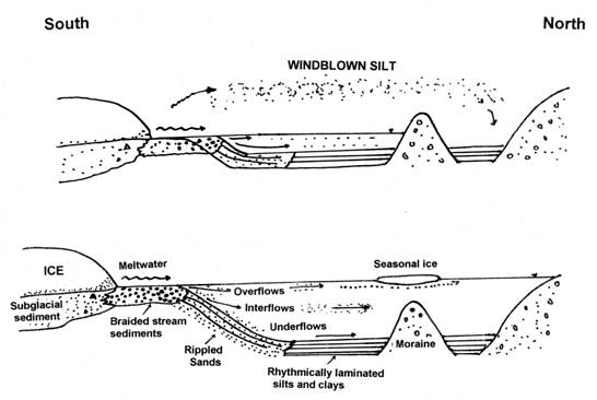
Figure 13.Ā Hypotheses for the origin of the silt and mud
unit that lacks diatoms.
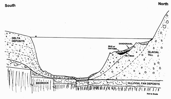
Figure 14.Ā Generalized south-north geologic
cross-section across the Wallowa
Lake area.
GEOLOGIC HISTORY OF WALLOWA LAKE:Ā A SUMMARY
ĀĀĀĀĀĀĀĀĀĀĀ As the Wallowa Mountains continued to uplift along the Wallowa
Fault and climate began to cool at the dawn of the Ice Ages around 3 million
years ago, erosion formed large alluvial fans at the base of the
mountains.Ā Glaciers formed as snow accumulated
faster than it melted and tongues of ice advanced down the mountain valleys and
out across the older alluvial fan sediments.Ā
The ice advanced and retreated several times, leaving behind the complex
series of glacial moraines that frame present-day Wallowa Lake
(Fig. 14).Ā As the glacial ice retreated
the final time, it grew thinner, leaving behind moraines at progressively lower
elevations.Ā These moraines may have been
deposited during brief pauses in the retreat of the ice.Ā Or, they may represent minor re-advances of
the ice that did not match the extent and height of those that preceded
them.Ā As the ice retreated up the
valleys into the High Wallowas and finally disappeared, sediment carried by
glacial meltwater streams was deposited in the south end of the lake, forming
delta deposits that built out into the lake and upward as the lake level
rose.Ā Fine-grained silt and mud, perhaps
deposited during low lake levels or by wind action, accumulated between the two
submerged moraines and were covered by mud rich in diatoms and conifer
pollen.Ā This mud fills a fault-bounded
graben in the deepest part of the lake, evidence that tectonic activity has
continued in the area in recent times.Ā
Today, the Wallowa
River is small compared
to what it must have been like as glaciers retreated from the area, but
deposition on the delta and in the lake continues, especially in the springtime
when the river is swollen by snowmelt and when summer thunderstorms rapidly
drop large amounts of precipitation into the high mountains that tower above
the lake.Ā
CONCLUSIONS
Our bathymetric profiling of Wallowa Lake
confirms that the lake floor is divided into two sub-basins as previously
suggested by Oregon
State University
researchers.Ā East-west profiles across Wallowa Lake
show that the lake floor has been filled with sediment as the glaciers
retreated and by sediment washed in from the Wallowa River
across the delta at the south end of the lake.Ā
In many areas, the lake floor slopes gently toward the west.Ā North-south profiles along the length of the
lake reveal two west-northwest-trending underwater moraines between the two
sub-basins.Ā These moraines are up to 6m
(20 ft) high and are covered with large boulders (glacial erratics).Ā The moraines can be traced out of the water
into subtle north-sloping topographic benches on the late Wisconsin (Drift unit W) glacial moraines on
the lake.Ā Our bathymetric profiling also
revealed two faults that trend N60E at an acute angle to the main trend of the
Wallowa Fault along the base of the mountains and the faults that have been
previously mapped in the Wallowa
Lake area.Ā The faults form the borders of an ~ 0.5 km
(0.3 mi) wide flat-floored valley (graben) in the deepest part of the south
basin.Ā
ĀĀĀĀĀĀĀĀĀĀĀ The
sediments in the bottom of Wallowa
Lake were previously identified
as
sands and gravels.Ā
Our studies have confirmed that the sediments in the shallow portions of
Wallowa Lake are coarse-grained.Ā Sand and gravel were found in depths up to 40
m (132 feet).Ā Below this depth, much of
the lake floor is covered with mud that is rich in diatoms, sponge spicules,
conifer pollen, and organic material.Ā
This mud is frequently laminated (varved?) or mottled and is overlain by
sand in some areas.Ā The diatom-rich mud
is underlain in the area between the two underwater moraines by a layer of silt
and mud that lacks diatoms.Ā On the
eastern side of the area between the two underwater moraines, the layer that
lacks diatoms directly underlies sand without the intervening diatom-rich mud
layer.
The layer of fine-grained mud and
silt that lacks diatoms at the bottom of our cores may record the deposition of
silt and finer particles washed over the southern submerged moraine as the lake
filled. Or, this layer could have been deposited by wind action.Ā This was followed by deposition of
diatom-rich sediments as the lake deepened and winnowing of sand by wave action
from the glacial tills that form the lake margins.Ā Another possibility is that the deposition of
sand on top of the older layers is related to the drop in lake levels indicated
by the lake sediments present above the level of the present day lake.
Unfortunately, we do not know the
ages of these sediments.Ā Dating the
organic material in the Wallowa Lake cores using radiocarbon and other techniques
would help us to better understand the events during the deposition of the
sediments in Wallowa
Lake.ĀĀ And, since the maximum depth penetrated by
our coring was only 61 cm (2 ft), it is likely that there are other sediment
layers beneath the ones that we sampled that may help fill in more of the
geologic history of Wallowa
Lake.Ā Longer cores obtained with a larger corer or
by vibracore drilling, coupled with seismic profiling of the lake floor, would
add a great deal to our knowledge of the geologic history of Wallowa Lake
and the surrounding area.
ACKNOWLEDGMENTS
ĀĀĀĀĀĀĀĀĀĀĀ We would
like to thank Carolyn Gilbert for her wonderful hospitality as we were
conducting our field research on Wallowa
Lake.Ā We gratefully acknowledge the Eastern Oregon
University Tech Fee Committee for making it possible for us to purchase the
depth sounder, side-scan sonar transponder, winch, and corer that made this
research possible.Ā Odom Hydrographic,
Inc., repaired our depth sounder several times over the course of this
investigation.
REFERENCES CITED
Allen, J.E., 1975, The Wallowa "Ice Cap" of
northeastern Oregon:Ā The Ore Bin, v. 37, no. 12, p. 189-202
Atlas of Mountain Glaciers in the Northern Hemisphere, 1958,
United States Quaternary
Research and Engineering Center, Nortick,
Massachusetts.
Bentley, E.B., 1974, The glacial morphology of eastern Oregon uplands:Ā
Ph.D. thesis, University
of Oregon, 250 p.
Budlong, B., Collier, J.R., Gilbert, D.E., and Van Tassell,
J., 2003, Possible glacial moraines and graben on the floor of Wallowa Lake, NE
Oregon:Ā Geological Society of America
Abstracts with Programs, v. 35, no. 4, p. 3.
Burke, R.M., 1980, Multiparameter relative dating techniques
used to differentiate tills Ā near Wallowa Lake, Oregon:Ā Geological Society of America Abstracts with
Programs, v. 12, no. 3, p. 99.
Burke, R.M., and Birkeland, P.W., 1983, Holocene glaciation
in the mountain ranges of the western United States, in Wright, H.E.,
Jr., ed., Late Quaternary environments of the United States, v. 2, The
Holocene, Minneapolis, University of Minnesota Press, p. 11.
Carson, R.J., 2001, Where the
Rockies meet the Columbia Plateau:Ā
Geologic field trip from the Walla Walla
Valley to Wallowa Mountains, Oregon:Ā Oregon Geology, v. 63, no. 1, p. 13-16,
21-35.
Crandell, D.R., 1967, Glaciation at Wallowa
Lake, Oregon:Ā U.S. Geological Survey Professional
Paper 575-C, p. C145-C153.
Eyles, N., and Eyles, C.H., 1992, 5.Ā Glacial depositional systems; in Walker, R.G., and James, N.P., Facies Models- Response to
Sea Level Change:Ā Geological Association
of Canada, St. Johns, Newfoundland, p. 73-100.
Johnson, D.M., and others, 1985, Atlas of Oregon Lakes: Corvallis, OR, Oregon State
University, 317 p.
Kiver, E.P., 1974, Holocene glaciation in the Wallowa
Mountains, Oregon, in Mahoney, W.C., ed., Quaternary Environments:
Proceedings of a Symposium, Geographical Monographs 5, Toronto, York
University-Atkinson College, p. 169-196.
Larson, D.W., 1981, Factors contributing to the maintenance
of oligotrophy in an Alpine glacial moraine lake (Wallowa
Lake) in northeast Oregon:Ā
Northwest Science, v. 55, no. 2, p. 95-107.
Licciardi, J.M, Clark, P.V., Brook, E.J., Elmore, D., and
Sharma, P., 2004, Variable ĀĀ responses of
western U.S.
glaciers during the last deglaciation:Ā
Geology, v. 32, no. 1, p. 81-84.
Lowell, W.R., 1939,
Glaciation in the Wallowa Mountains: Unpublished M.S. thesis, University of Chicago,
90 p.
Orr, E.L., Orr, W.N., and Baldwin, E.M., 1992, Geology of
Oregon, 4th edition:Ā Dubuque, IA,
Kendall-Hunt, 254 p.
Phillips, K.N., Newcomb, R.C., Swenson, H.A., and Laird,
L.B., 1965, Water for Oregon:Ā U.S. Geological Survey Water-Supply
Paper 1649, 150 p.
Sibrava, V., Bowen, D.Q., and Richmond, G.M., 1986, Quaternary glaciations
in the northern hemisphere: Report of the International Geological Correlation
Programme Project 24, p. 121.
Smith, W.D., 1918, The Wallowa Mountains, Geology and
economic geography:Ā Mazama Magazine, v.
5, no. 3, 37 p.
Smith, W.D., Allen, J.E., Staples, L.W., and Lowell, W.R., 1941, Geology and physiography of the
northern Wallowa Mountains, Oregon:Ā Oregon Department of Geology and Mineral
Industries Bulletin no. 12, 64 p.
Stadter, F.W., 1931, Glaciation in the Wallowas:Ā Mazama Magazine, v. 13, no. 12, p. 26-31.
Stovall, J.C., 1929, Pleistocene geology and physiography of
the Wallowa Mountains (Oregon), with special
reference to the Wallowa and Hurricane
Canyons:Ā Ā Unpublished
M.A. thesis, University
of Oregon, 81 p.
Talbot, M.A., and Allen, P.A., 1996, Chapter 4.Ā Lakes, in Reading, H.G., ed., 1996, Sedimentary
Environments: Processes, Facies & Stratigraphy, 3rd edition:Ā Oxford, Blackwell Science Ltd., p. 83-153.
Walker, G.W., 1979,
Reconnaissance geologic map of the Oregon part
of the Grangeville quadrangle, Baker, Union, Umatilla, and Wallowa counties, Oregon:Ā U.S. Geological Survey Miscellaneous
Investigations Map I-1116, 1:250,000.
Williams, L.D., 1974, Neoglacial landforms and Neoglacial
chronology of the Wallowa Mountains, northeastern Oregon:Ā M.S. thesis, University
of Massachusetts, Amherst, 274 p.
Back to Eastern Oregon Geology home page