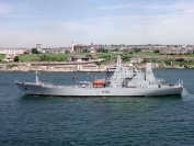
Hydrographic Vessels
Hydrographic and oceanographic surveying is the responsibility of the Royal Navy's Surveying Service, which has been operating throughout the world since the formation of the Hydrographic Department in 1795. The information from the surveys is used for producing Admiralty charts and nautical publications which have a world-wide sale and are used by ships of many nations.
The Surveying Flotilla consists of ocean-going ships, coastal vessels and inshore craft. In addition to surveying in overseas areas, ships of the flotilla are constantly engaged in updating the charts covering the waters around the United Kingdom. To carry out these wide-ranging tasks the latest surveying techniques are employed, including digitised echo sounders, side scan sonars, automated plotting and recording of position, depth, gravity and magnetic parameters. Satellite and inertial navigation systems are used when out of range of shore-based position fixing systems.


