| Catalogue of Canadian volcanoes |
Print version   |  | 
Earth Sciences Sector > Priorities > Strong and safe communities > Volcanoes of Canada
Catalogue of Canadian volcanoes Garabaldi volcano belt: Mount Meager volcanic field

Figure A6. Mount MeagerThe eruption of Mount Meager volcano that occurred in 2350 BP emanated from the top of the dark triangular area in the centre of this photograph taken looking westward. It sent a column of ash at least 20 km high above the volcano. Ash was carried downwind as far as Alberta, and nearby regions were devastated by heavy ash fall, pyroclastic flows, collapsing lava flows, and catastrophic flooding.
(Photograph by C.J. Hickson (Geological Survey of Canada))
|
|
Mount Meager, 150 km north of Vancouver, British Columbia, is the youngest
of four overlapping stratovolcanoes resting on a 400 m high
ridge of nonvolcanic, crystalline and metamorphic rock. The
complex comprises at least eight vents that have produced basaltic
to more evolved andesitic, dacitic, and rhyolitic magmas. Andesite
lava flows (500,000 to 1,000,000 years old) are the most abundant
rock type and their maximum total flow thickness is over 1 km.
The most recent volcanic activity started 2350 radiocarbon years
ago from a vent on the northeast side of the mountain and consisted
of a massive, dacitic, Plinian eruption (Figure A6).
The ash plume from this explosion travelled east across British Columbia
into Alberta. The next stage of the eruption was marked by the
production of hot, mobile, pyroclastic flows that travelled
7 km downstream from the vent (Figure A7, Figure A8).
This early phase was followed by the extrusion of a lava flow
(Figure A9) that repeatedly collapsed on the steep slopes, producing a unique,
dense, welded breccia thick enough and extensive enough to dam
the Lillooet River valley, resulting in the formation of a lake
upstream along the Lillooet River. One dam failure on the upper
Lilloet River produced a cataclysmic outburst flood that sent
small-house-sized boulders downvalley for several kilometres
and destructive floodwaters even farther. The final stages of
the eruption produced a short lava flow. Two peripheral clusters
of hot springs are found within the complex and suggest that
magmatic heat is still present. Canada's only producing pumice
mine is on the northeast side of Mount Meager.

Figure A7. Mount Meager ashThe initial vent-clearing Pinian eruption at Mount Meager deposited ash several metre in thickness close to the vent area. Th black vertical objects seen to the right and above the person are carbonized tree trunks. The trees were first buried by falling ash (the layer extending from the person's feet to his waist), then were overcome by even thicker accumulations of pumice blocks from at least two pyroclastic flows. Above the pyroclastic-flow deposit is a welded breccia unit formed from the collapsing front of the lava flow that emanated from the vent area on the slopes far above.
(Photograph courtesy of P. Read)
|
|

Figure A8. The formation of Keyhole FallsThis solid-looking rock cliff actually started as an unconsolidated volcanic breccia. Formed from the collapsing lava-flow front, the breccia collected downslope from vent in the Lillooet River valley. The hot breccia accumulated so rapidly that it welded into a solid unit. This unit formed a rock dam behind which water from the Lillooet River ponded. Later breccia was not so well consolidated and the rising flood waters soon broke through the overlying material. The flood was massive enough that small-house-sized blocks of the underlying welded breccia were carried away as the flood eroded downward through the deposit. The Lillooet River has now cut a notch through the unit, forming Keyhole Falls.
(Photograph by C.J. Hickson (Geological Survey of Canada))
|
|

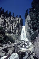
Figure A9. Lava columns & Fall CreekA short, stubby lava flow was the last volcanic event to rock the Mount Meager area. The dacitic lava cooled into well formed columns over and through which Fall Creek has cut a path.
(Photograph courtesy of P. Read)
|
|
The explosive nature of past eruptions at Mount Meager suggests that this
volcano poses a significant long-distance threat to communities
across southern British Columbia and Alberta. It also poses
a significant local threat to the town of Pemberton, British
Columbia, about 50 km downstream from the volcano. The failure
of natural dams formed on the upper Lillooet River by landslides
not associated with volcanic activity could produce catastophic
floods. In addition, volcano-generated debris flows (lahars)
could travel as far as Pemberton. Another explosive eruption
at Mount Meager would also have a significant impact on local
mining and logging operations, as well as significant negative
impacts on the Lillooet River fishery (the river has salmon
runs at least to Lillooet Lake, if not farther west).
|
