|
The Bay of Fundy, on Canada's eastern seaboard, is the site of the world's highest
recorded tides. On 5 October 1869, a storm with hurricane force winds travelled up
the Bay of Fundy causing a 2 metre tidal surge resulting in extensive flooding.
This event is known as the Saxby Gale.
The lowlands at the head of the Bay of Fundy are very susceptible to
flooding by storm surges. High resolution digital elevation models (DEMs)
acquired by remote sensing are a valuable tool when used to accurately
estimate potential
flooding over such extended areas. To evaluate the use of ALTM to this
purpose, much of the floodplain and dykelands of Truro, Nova Scotia was
surveyed which provided an extremely accurate elevation model.
The flood water levels associated with the Saxby Gale storm surge have been superimposed
on the terrain model to reconstruct the extent of flooding that occurred with the event.
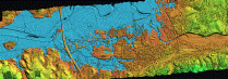
The left image above shows the Truro region in it's normal state and the right
image shows the area (in blue) which is supposed to have flooded during the Saxby Gale. Click on
either image to see a larger view.
The town of Truro is built on the floodplains of the Salmon River.
Extensive dykes contain the river within its channel and protect the
rich farmlands of the marshes from inundation by seawater during the high
tides that occur in the area. These dykes have served the town well for the past 2-3
centuries.
However, there have been some notable exceptions when the dykes could not hold back
the onset of the tide. One of these events occurred during the Saxby Gale, of 5
October 1869, when a 2 metre storm surge coincided with an extreme
high tide event. Extensive flooding and storm damage occurred. A brief history
of the events leading to the gale were presented at the
23rd Conference
on Hurricanes and Tropical Meteorology.

(ATLM data of Truro-Click to expand)
This colour shaded relief image was created from ALTM data
collected in December 1998. The image uses colour to show the relative
heights of features in the area. Features shown in red
have the lowest elevation and those in green depict the highest elevations.
The above image (click to enlarge) shows the general layout of the town with
the commercial district and residential areas situated on the floodplain of the Salmon River.

(ATLM data of Truro showing a perigean Spring tide-Click to expand)
Every 18 years, the orbits of the sun, earth and moon
align to produce an extreme high tide known as a perigean spring tide.
In this colour shaded relief image of Truro, NS, the blue colour shows
the area that would flood during a perigean spring tide if there
were no dykes present. Note that there are no breaches
in the dykes along the Salmon River, indicating that they are
high enough to hold back these tides. Without
the existing dykes, much of the agricultural lands near
the river and an area south of the commercial district would flood.
(ATLM data of Truro showing a 2 metre storm surge, The Saxby Gale-Click to expand)
During the Saxby Gale of 5 October 1869 a 2 metre storm surge
coincided with the perigean spring tide. In this image, the blue colour
shows the approximate area that would flood if these conditions re-occur.
Much of the present commercial area and most of the residential area built
on the flood plains would be submerged. All dykes would
be overtopped. Historical documents on the Saxby Gale, report
that flood water remained trapped behind the dykes for several days after the storm.
The sequence of images below show the effects of rising tide levels on the main
commercial area of Truro.

(Air photo data of Truro-Click to expand)
This aerial photograph, taken on 5 June 1994, shows the commercial area of Truro
near Highway 102, as well as the brownish waters of the Salmon River, dyked farmlands, shopping malls
and commercial areas.

(ALTM data of Truro showing a normal high tide-Click to expand)
ALTM data, from the same area as shown in the air photo, were used to create this
shaded relief image. The data were processed to provide a horizontial
resolution of 2.5 metres
with a vertical resolution of several centimeters. This allows detection of objects
the size of small cars. The features shown in the
overview image above
are quite evident in this image. Note that the water level in the Salmon River
is shown in blue.

(ALTM data of Truro showing a perigean Spring tide-Click to expand)
Truro has a dyke system designed to prevent flooding from daily high tides of
the Bay of Fundy. The blue colour in the ALTM image shows
the area that would be flooded by a perigean spring tide if the dykes were not present.

(ALTM data of Truro showing 1 metre storm surge-Click to expand)
The blue colour
in this image shows then area that would flood by a 1 metre storm surge
coincident with a perigean spring tide. Note that parts of the dykes have been
inundated. As the tide drops, the dykes would retain the flood waters.

(ALTM data of Truro showing 2 metre storm surge
The Saxby Gale-Click to expand)
Records from the Saxby Gale indicate that the water levels were
equivalent to a 2 metre storm surge superimposed on a perigean
spring tide. The blue colour shows the area that would flood
during such an event. Most of the dykes would be inundated,
large areas of Truro would flood, and the dykes would retain the water,
compounding the problem.
(Air photo and ALTM data of Truro showing
The Saxby Gale-Click to expand)
This image, a montage created from ALTM data and an air photo of Truro,
presents a birds-eye view of conditions that would occur during an event
like the Saxby Gale. ALTM data is shown for areas that would be flooded and
overlain on an air photo. Data were manipulated within the GIS
system to produce this image.
For more information, go to Affiliations and Contacts
|


